| WPC Met Watch |
|
|
Mesoscale Precipitation Discussion: #0616 |
|
(Issued at 742 PM EDT Mon Jul 07 2025
) |
|
| MPD Selection |
|
|
|
|
|

Mesoscale Precipitation Discussion 0616
NWS Weather Prediction Center College Park MD
742 PM EDT Mon Jul 07 2025

Areas affected...Western Kentucky...Northwest Tennessee...

Concerning...Heavy rainfall...Flash flooding possible

Valid 072345Z - 080500Z

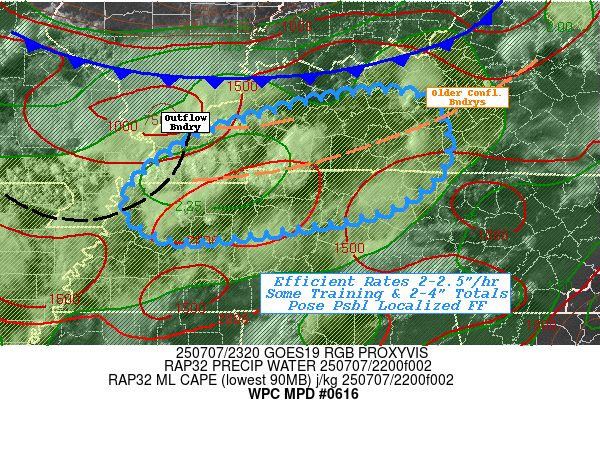
SUMMARY...Broader overturning along/southeast of outflow
boundaries may support short-term repeating/training & possible
mergers allowing for localized 2-4" totals and possible flash
flooding into early overnight period.

DISCUSSION...GOES-E Vis/EIR and RADAR animation depicts a mature
convective complex with strong outflow boundary crossing southeast
MO.  Stronger deep layer convergence across a moderately unstable
environment with 2000-2500 J/kg of MLCAPE has resulted in a few
bands of stronger/broader convective overturning of the unstable
air across Southwest KY and Northwest TN.  Visible loops show
cells have oriented along some older either confluence or outflow
boundaries that extend eastward generally parallel to deeper layer
steering flow.  Aloft, there is a col in upper-level flow as the
far northern periphery of the Tropical Upper-Tropospheric Trough
(TUTT) cell that can be seen over the northwest Gulf south of LA
with edge over N MS, while northern stream shortwave cross MO,
with entrance to polar jet in the vicinity.  This has maximized
upper-level divergence in W KY/NW TN to further aid convective
organization.

Deep layer confluence into the northern stream through the Lower
Ohio Valley has maximized total PWat values over 2", perhaps
nearing 2.25". This will make cells very efficient with deep warm
cloud processes supporting 2-2.5"/hr rates (with an isolated 3"/hr
spot possible).  Given deep layer flow into the northern stream is
also fairly parallel to the aforementioned confluence boundary and
slowly sagging cold front crossing the Ohio River; some repeating
and training is possible over the next few hours.  That increased
duration may support some streaks of 2-4" totals in less than
3hrs.  Given FFG values of 2-3"/3hrs across the area, this
suggests localized flash flooding is considered possible.
Convection should wane with loss of daytime heating and
overturning of the unstable air, but may still intersect remaining
untapped unstable air eastward, but overall trends should slowly
diminish after dark.

Gallina

ATTN...WFO...LMK...MEG...OHX...PAH...

ATTN...RFC...ORN...TIR...NWC...

LAT...LON   37538612 37148574 36718575 36408604 36148661
            35908809 35858892 36128940 36468938 36838891
            37108843 37498702
Download in GIS format: Shapefile
| KML
Last Updated: 742 PM EDT Mon Jul 07 2025
|


