| WPC Met Watch |
|
|
Mesoscale Precipitation Discussion: #0626 |
|
(Issued at 148 AM EDT Wed Jul 09 2025
) |
|
| MPD Selection |
|
|
|
|
|

Mesoscale Precipitation Discussion 0626
NWS Weather Prediction Center College Park MD
148 AM EDT Wed Jul 09 2025

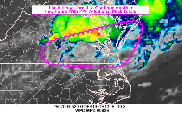
Areas affected...central to southeastern VA into southern DelMarVa
Peninsula

Concerning...Heavy rainfall...Flash flooding possible

Valid 090547Z - 091015Z

Summary...A threat of flash flooding will continue across portions
of central to southeastern VA and possibly into the southern
DelMarVa Peninsula through 09-10Z. Rainfall rates of 1-2 in/hr
(locally higher possible) and additional totals of 2-4 inches are
expected.

Discussion...Local radar imagery at 0520Z showed a region of
thunderstorms extending west-east from central VA to just west of
the Chesapeake Bay. MRMS has been matching local gauge reports
fairly well over the past 2-3 hours in showing peak hourly
rainfall totals in the 1-2 inch range. An outflow boundary was
noted to be pushing south of the Richmond/Petersburg metro but
additional storms to the west were likely being aided via a
southwesterly axis of low level moisture feeding directly into the
region at 20 kt/isentropic ascent, beneath weakly diffluent flow
aloft. MLCAPE trends have come down significantly over the past 3
hours with 05Z SPC mesoanalysis data showing less than 500 J/kg
MLCAPE in place over most of VA. However, relatively steep lapse
rates in the 850-700 mb layer (6.5-7.5 C/km) were contributing to
elevated instability of up to 1000 J/kg across much of the region.

Thunderstorms are expected to continue advancing east over the
next few hours but with some southward translation due to cold
pools and propagation into the inflow. While weakening of
convective intensity is anticipated overall by 09/10Z, flash flood
potential will continue to linger from 1-2 in/hr rainfall rates
(locally higher possible) and the potential for an additional 2-4
inches over the next 3-5 hours. If storms are able to survive,
they will bring potential flash flood impacts to the
Hampton/Norfolk/Virginia Beach regions of southeastern VA,
although recent available hires models do not support storms
maintaining significant intensity that far east.

Otto

ATTN...WFO...AKQ...RNK...

ATTN...RFC...ALR...RHA...NWC...

LAT...LON   38137536 37817510 37257534 36547584 36507701
            36637865 37227873 37637750
Download in GIS format: Shapefile
| KML
Last Updated: 148 AM EDT Wed Jul 09 2025
|


