| WPC Met Watch |
|
|
Mesoscale Precipitation Discussion: #0631 |
|
(Issued at 755 PM EDT Wed Jul 09 2025
) |
|
| MPD Selection |
|
|
|
|
|

Mesoscale Precipitation Discussion 0631
NWS Weather Prediction Center College Park MD
755 PM EDT Wed Jul 09 2025

Areas affected...Southern Appalachians into the Carolinas Piedmont

Concerning...Heavy rainfall...Flash flooding possible

Valid 092354Z - 100600Z

Summary...Showers and thunderstorms will increase in coverage
through the next several hours. Rainfall rates within deeper
convection will exceed 2"/hr leading to localized rainfall as much
as 3-4". Flash flooding is possible.

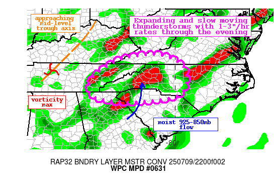
Discussion...The GOES-E IR imagery this evening shows a slow
uptick of cooling cloud tops from northern AL through
western/central NC. These cooling tops are associated with
deepening convection within a belt of higher moisture clearly
noted on the GOES-E WV imagery stretching from MS into New
England. Embedded in this plume, a potent vorticity max is
pinwheeling across central TN, accompanying the primary mid-level
trough axis that is concurrently swinging eastward. This is
driving mid-level height falls from eastern TN into the Carolinas
and western VA, which is combining with S/SW 925-850mb flow and
the resulting upslope/convergence into the terrain to produce
significant ascent. Additionally, a pre-frontal trough and
accompanying squall line are moving across central NC. This lift
is acting upon a moist and unstable atmosphere characterized by
PWs of 1.8-2.2 inches and MLCAPE that remains above 2000 J/kg,
resulting in widespread thunderstorm development noted via the
regional radar mosaic.

Radar estimated rain rates have been as much as 2"/hr according to
KGSP and KMRX, and these are likely to continue for several more
hours as reflected by HREF 2"/hr neighborhood probabilities
peaking above 30%. This is despite the slow wane of surface
instability, as the residual elevated CAPE will be plentiful to
support heavy rain. As the shortwave and mid-level trough axis
over TN swing eastward, forcing for ascent should maximize over
western NC and the surrounding mountains/foothills, leading to an
increase in convective coverage. This is suggested by many
high-res CAMs, and activity is expected to linger well beyond the
typical diurnal maximum. As convection expands, bulk shear may
approach 25 kts to help drive at least modest organization into
clusters, but with mean 0-6km winds and accompanying Corfidi
vectors remaining just 5-10 kts, storm motions will be slow and
chaotic. This is concerning for the flash flood potential as the
intense rain rates will continue, helping to drive the HREF
neighborhood probabilities for 3"/6hr (5"/6hr) above 40% (10%).

FFG across the region varies greatly since the mountains have been
dry the last 7 days, but the Piedmont is vulnerable due to recent
heavy rain. Despite the varying FFG, HREF 3-hr FFG exceedance
probabilities peak at 15-30% across much of the region. This
suggests a flash flood risk exists across the entirety of the
area, with the vulnerable soils east, and sensitive terrain west,
increasing the runoff risk through the evening.


Weiss

ATTN...WFO...CAE...FFC...GSP...JKL...MRX...RAH...RLX...RNK...

ATTN...RFC...ALR...ORN...TIR...NWC...

LAT...LON   37118106 36617969 35857935 35087952 34728008
            34508150 34438283 34558372 34678435 34898482
            35688476 36588357 36948259
Download in GIS format: Shapefile
| KML
Last Updated: 755 PM EDT Wed Jul 09 2025
|


