| WPC Met Watch |
|
|
Mesoscale Precipitation Discussion: #0632 |
|
(Issued at 848 PM EDT Wed Jul 09 2025
) |
|
| MPD Selection |
|
|
|
|
|

Mesoscale Precipitation Discussion 0632
NWS Weather Prediction Center College Park MD
848 PM EDT Wed Jul 09 2025

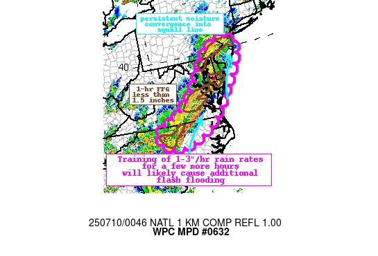
Areas affected...Mid-Atlantic States

Concerning...Heavy rainfall...Flash flooding likely

Valid 100047Z - 100630Z

Summary...A line of thunderstorms along a pre-frontal trough will
continue to move E/NE through the evening. Rainfall rates of
1-3"/hr are likely within these storms, leaning to stripes of 2-4"
of rain and additional instances of flash flooding.

Discussion...The regional radar mosaic this evening shows an
impressive squall line with continuous thunderstorms aligned from
near Philadelphia, PA southwest to Charlotte, NC. This line has
been slowly but steadily moving east, while cells along the line
track northeast. As this line has moved east, it has left a swath
of MRMS measured rainfall of 1-3" with locally as much as 4" in
the past 6 hours, and radar-estimated rain rates from radars along
the line continue to be 1.5-2.0"/hr.

There is good agreement that the squall line will continue to
pivot slowly eastward, although some faster progression has been
noted recently across NC/VA. Thermodynamics downstream of the line
remain impressive and favorable for the continuation of heavy
rain. MLCAPE is above 2000 J/kg in a narrow corridor generally
along and east of I-95, with collocated PWs of 1.9 to 2.2 inches,
or +1.5 standard deviations according to the SREF. 850mb inflow is
measured out of the S/SW at around 20 kts according to regional
VWPs downstream of the line, which when combined with the highly
anomalous PWs will continue to push anomalous 850-700mb moisture
flux into the region. This will support the persistence of heavy
rain rates above 2"/hr as progged by HREF 2"/hr neighborhood
probabilities of 30-40%, with brief rain rates above 3"/hr
possible as reflected by HRRR 15-min rainfall reaching 0.75" or
more.

Bulk shear along and ahead of the line will remain 20-30 kts
through the evening, suggesting multi-cell clusters (and isolated
supercells) will continue, and this organization may briefly
intensify and temporally extend the heavy rain rates. This will be
in addition to training of cells that is expected from SW to NE
due to parallel 0-6km mean winds and Corfidi vectors from VA
northeast. Farther south into NC, Corfidi vectors pivot to become
aligned anti-paralle to the mean wind, indicating that
regenerating and backbuilding cells into the greater instability
is also expected. Either way, this suggests a high potential for
training the next several hours, leading to rainfall that could
reach 2-4", or locally higher, according to HREF 6-hr neighborhood
probabilities.

0-10cm soil moisture percentiles over this area are generally well
above normal, and above the 98th percentile in parts of NC and
from Washington, D.C northeast through coastal NJ. This is
reflected by extremely compromised 1-hr FFG that is 1.5" or less,
suggesting even outside of the urban areas the soils have limited
infiltration capacity and are vulnerable to rapid runoff/flash
flooding. With these intense rain rates expected to continue for
several more hours as the line translates eastward, any training
would likely overwhelm these soils quickly, leading to additional
flash flooding across the region.


Weiss

ATTN...WFO...AKQ...CTP...GSP...LWX...MHX...PHI...RAH...RNK...

ATTN...RFC...ALR...RHA...NWC...

LAT...LON   40527440 40277397 39617407 39097437 37317565
            36307665 35677769 35257893 35397955 35668005
            35948038 36388017 36757932 37297844 38157752
            39327662 40167588 40467534
Download in GIS format: Shapefile
| KML
Last Updated: 848 PM EDT Wed Jul 09 2025
|


