| WPC Met Watch |
|
|
Mesoscale Precipitation Discussion: #0633 (2020) |
|
(Issued at 320 AM EDT Fri Aug 14 2020
) |
|
| MPD Selection |
|
|
|
|
|

Mesoscale Precipitation Discussion 0633
NWS Weather Prediction Center College Park MD
320 AM EDT Fri Aug 14 2020

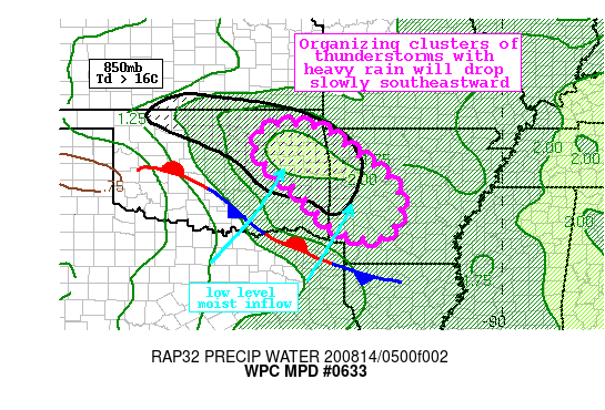
Areas affected...Eastern Oklahoma, Northwest Arkansas

Concerning...Heavy rainfall...Flash flooding possible

Valid 140719Z - 141300Z

Summary...Clusters of showers and thunderstorms are developing
across northeast Oklahoma this morning in a region of warm air
advection. These thunderstorms are expected to increase in
coverage and intensity, with rain rates possibly peaking above
2"/hr. Flash flooding is possible.

Discussion...GOES-16 IR imagery early this morning indicates
clusters of cloud tops beginning to cool to below -60C across
northeast Oklahoma associated with rapidly blossoming and
deepening thunderstorms. This convection is being fueled by an
intensifying southerly LLJ ascending isentropically atop both a
surface stationary boundary and an elevated baroclinic zone across
OK/AR, working in conjunction with a modest shortwave dropping
southeast atop the boundary. In this region, PWs have surged
towards 2", highest in AR and eastern OK according to recent GPS
observations, enhanced by 850mb dewpoints greater than 16C, which
are above the 90th percentile for the date and approaching daily
records.

Recent VWPs indicate that the 850mb LLJ was 30 kts or more across
southern OK and into TX, coincident with MUCape > 3000 J/kg. As
these favorable thermodynamics lift northward, they will resupply
the environment to maintain rain rates which could approach 3"/hr
according to recent HREF neighborhood probabilities. Bulk shear
values along the nose of this LLJ will also continue to rise,
potentially exceeding 50kts to drive better storm organization,
helping to enhance these rain rates. Despite relatively fast
850-300mb mean wind of around 20 kts, Corfidi vectors aligned to
the right of this mean flow suggests training is likely to the
southeast, so repeated rounds of heavy rainfall are possible as
the MCS progresses only slowly to the east. This training,
especially if it occurs with rain rates >2"/hr, could produce
total rainfall in excess of 4" in a narrow band, although heavy
rainfall of 1-3" is expected to be more common.

Parts of OK/AR have received excessive rainfall recently, and
7-day rainfall departures are as high as 600% of normal. The
high-res multi-model consensus is for the axis of heaviest rain to
occur just east of the recent heaviest rainfall, but even here FFG
is as low as 1.5"/1hr or 2"/3hrs which could be exceeded, and HREF
3-hr exceedance probabilities have risen to 30%. Flash flooding is
possible, and would become more likely should training occur over
areas that have received this excessive rainfall during the past
week.

As the LLJ begins to veer after daybreak, the cluster is progged
to become more outflow dominant. This should allow the MCS to
begin to propagate more quickly to the southeast and the flash
flood threat may wane by late morning into parts of southern AR.

Weiss

ATTN...WFO...LZK...SHV...TSA...

ATTN...RFC...ABRFC...LMRFC...NWC...

LAT...LON   36599562 36589512 36449463 36189419 35949394
            35489325 35049280 34629262 34299266 34009277
            33759300 33719326 33729374 33869415 34119454
            34499486 35039538 35309575 35559603 35819622
            36179636 36399622 36519596
Last Updated: 320 AM EDT Fri Aug 14 2020
|


