| WPC Met Watch |
|
|
Mesoscale Precipitation Discussion: #0633 |
|
(Issued at 210 AM EDT Thu Jul 10 2025
) |
|
| MPD Selection |
|
|
|
|
|

Mesoscale Precipitation Discussion 0633
NWS Weather Prediction Center College Park MD
210 AM EDT Thu Jul 10 2025

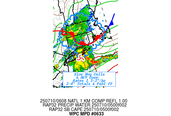
Areas affected...Southern New England...Eastern Long Island...

Concerning...Heavy rainfall...Flash flooding possible

Valid 100610Z - 101200Z

SUMMARY...Strong MCS approaching Long Island & slow moving,
isolated convection north of it across Southern New England.
Rates of 1.5-2"/hr and totals of 2-3.54" may present localized
possible flash flooding through early morning.

DISCUSSION...GOES-E 10.3um EIR loop shows a mature symmetric MCC
moving through the New York Bight toward eastern Long Island.
RADAR shows impressive MCV and stronger thunderstorm activity
extending eastward given stronger WAA along/ahead of the wave
increasing appearance of a solid occlusion to the overall wave.
This would suggest slowing northeastward propagation and
increasing rainfall duration.  Given ample deep layer moisture of
1.75" and stronger flux noted by RAP analysis and upstream VWP out
of NJ; would support up to 2"/hr and possible 2-3" totals along
the MCV across LI and eventually into coastal SE CT/RI and SE MA.
Given higher FFG naturally through the area, flash flooding
potential is likely to be more urban in nature with this wave.

Further north into southern New England; RAP analysis and surface
observations support a remaining uncapped to slightly capped
region of 1000+ J/kg SBCAPE along the slowly northward advancing
warm front from the Upper-Hudson Valley across central CT toward
the Gulf of Maine.   GOES-E WV shows highly positive
tilt/elongated trough axis across New England into the northern
Mid-Atlantic supporting DPVA while strong exiting jet streak over
90 kts at 3H across Interior New England providing strong right
entrance ascent and evacuation to the environment.  Proximity to
the warm front also provides some weak low level shear to support
helicity to 50 m2/s2.   As such, RADAR shows a few cells
developing across E NY, CT and MA that are narrow in nature but
have a weak rotation.  Given similar ample moisture, cells should
have good efficiency and weak rotating updrafts will further
enhance moisture flux.   While overall deep layer flow is strong
suggestive of progressive cell motions, the shear supports
Bunker's right moving supercell propagation suggests reduced
forward propagation allowing for increased rainfall duration.

So cells will have capability of 1.5-2"/hr rates but the weaker
instability will limit the overall width of the updraft and
potentially counteract the overall rainfall footprint/streaks.
Confidence is slightly increased given 00z Hi-Res CAM solutions
and 00z HREF output suggesting 3"/3hr of 10-30% and totals of 2-4"
remain possible through 12z.   Given this is very close to areas
affected by heavy rainfall last evening, soils may still be prone
for decreased infiltration and higher run-off suggesting areas of
possible flash flooding may occur again tonight.

Gallina

ATTN...WFO...ALY...BOX...GYX...OKX...

ATTN...RFC...TAR...NWC...

LAT...LON   43217211 42727125 42097060 41717053 41317090
            41157146 40857219 40707286 41387305 41667377
            42257386 42837312
Download in GIS format: Shapefile
| KML
Last Updated: 210 AM EDT Thu Jul 10 2025
|


