| WPC Met Watch |
|
|
Mesoscale Precipitation Discussion: #0636 |
|
(Issued at 201 PM EDT Thu Jul 10 2025
) |
|
| MPD Selection |
|
|
|
|
|

Mesoscale Precipitation Discussion 0636
NWS Weather Prediction Center College Park MD
201 PM EDT Thu Jul 10 2025

Areas affected...Central Appalachians through the Carolina
Piedmont

Concerning...Heavy rainfall...Flash flooding possible

Valid 101800Z - 110000Z

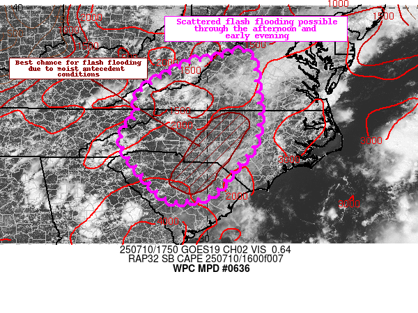
Summary...Scattered instances of flash flooding expected across
the interior southern Mid Atlantic into the Carolina Piedmont.

Discussion...Visible satellite this afternoon continues to depict
some hindrance of typical diurnal heating with scattered to
widespread cloud cover extending south to north across the
Carolinas into the Delmarva. Back into the interior southern Mid
Atlantic, pockets of clearing can be seen over the western
Carolinas with some enhanced cumulus development, mainly along and
west of I-85. Better solar insulation materialized across far
southern WV into southwest VA earlier today allowing for scattered
convective development where destabilization was maximized. The
expected convective cadence this afternoon is for slow clearing to
eventually give way to regional destabilization allowing scattered
shower/thunderstorm pulses to initiate within the outlined area.

Sufficient buoyancy and reputable PWATs hovering between 1.8-2.1"
will present a reasonable environment for scattered heavy
convective cores later this afternoon, leading to rates between
1-2 inches/hour, on average. A few stronger cells across the
Carolina Piedmont could very well push closer to 2-3 inches/hour
however, especially in proximity to a defined surface trough
bisecting the region longitudinally based off the latest surface
analysis. This will put areas across the central portions of NC/SC
at the greatest threat for heavy rain and flash flooding and
overlapping areas that has seen their FFG's lower as a result of
previous convective impacts.

Recent hi-res deterministic models have inferred on the threat of
scattered convective activity materializing by mid-afternoon,
carrying into the early evening before waning as the activity will
be subject to mainly thermodynamic processes with a weak kinematic
aid of a meager shortwave rippling eastward out of the Tennessee
Valley. Shear will be negligible today which correlates to more
pulse convective modes and slower storm motions once activity
initiates. Any steering pattern is weak, but will offer a slow
advancement eastward as we move through the afternoon. Once we
reach sunset, expecting convection to slowly dissipate over the
eastern Carolinas with the loss of diurnal heating considering the
overall environmental evolution. This will leave a window of 6-8
hrs for the greatest convective threat, enough for HREFpmm output
of 2-4+" scattered over the western Carolinas down through the
Piedmont.

The combination of slower mean storm motions and wet antecedent
conditions over much of western and central NC down through the
central SC Piedmont offers the risk of scattered flash flood
instances with the greatest threat within more urbanized zones.
Given lack of a true kinematic forcing and environmental bulk
shear, organized multi-cell clusters will be less common, thus
limiting the threat to flash flooding possible with more isolated
to scattered signals across portions of the southern Mid Atlantic.

Kleebauer

ATTN...WFO...AKQ...CAE...GSP...ILM...LWX...MRX...RAH...RLX...
RNK...

ATTN...RFC...ALR...ORN...RHA...TIR...NWC...

LAT...LON   38527878 38117846 37187834 36647827 36427825
            36017830 35697834 35437843 35117863 34737900
            34527919 33987959 33787982 33648008 33588038
            33558059 33528087 33518109 33608137 33728156
            33908176 34068189 34238201 34398217 34548235
            34808247 35238278 35688285 36018270 36238247
            36418229 36628230 36808236 37028240 37248217
            37458188 37638162 37728133 37868113 37968096
            38058083 38218041 38267974 38427930
Download in GIS format: Shapefile
| KML
Last Updated: 201 PM EDT Thu Jul 10 2025
|


