| WPC Met Watch |
|
|
Mesoscale Precipitation Discussion: #0637 |
|
(Issued at 218 PM EDT Thu Jul 10 2025
) |
|
| MPD Selection |
|
|
|
|
|

Mesoscale Precipitation Discussion 0637
NWS Weather Prediction Center College Park MD
218 PM EDT Thu Jul 10 2025

Areas affected...Northern Delmarva...Southern NJ

Concerning...Heavy rainfall...Flash flooding likely

Valid 101818Z - 102218Z

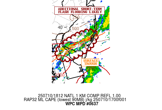
SUMMARY...Slow-moving and locally training showers and
thunderstorms are expected to continue over the next few hours.
Additional areas of flash flooding are likely over the next few
hours.

DISCUSSION...The latest radar imagery shows an axis of slow-moving
and locally training showers and thunderstorms impacting portions
of the northern Delmarva and southern NJ. The convection has been
showing some cooling cloud tops over the last hour and is
generally focusing along a surface trough oriented in a
west-southwest to east-northeast fashion across the region.

Convergent low-level flow along this surface trough coupled with
the pooling of a moderately buoyant airmass characterized by
MLCAPE values of 1000 to 1500 J/kg should promote some additional
expansion of convection at least over the next few hours. The
airmass is quite moist too with PWs of 2.0 to 2.25 inches. This
environment will favor high rainfall rates of 1.5 to 2.5
inches/hour.

The latest HRRR guidance and a couple of the 12Z HREF members are
hinting at this axis of convection continuing to locally train
over the same area, and suggest some additional rainfall potential
of as much as 3 to 4+ inches.

Additional areas of flash flooding are likely at least over the
next few hours given the rainfall potential and locally sensitive
antecendent conditions.

Orrison

ATTN...WFO...PHI...

ATTN...RFC...RHA...NWC...

LAT...LON   39707471 39657428 39527418 39317440 39167471
            39037553 39257590 39527553
Download in GIS format: Shapefile
| KML
Last Updated: 218 PM EDT Thu Jul 10 2025
|


