| WPC Met Watch |
|
|
Mesoscale Precipitation Discussion: #0638 |
|
(Issued at 305 PM EDT Thu Jul 10 2025
) |
|
| MPD Selection |
|
|
|
|
|

Mesoscale Precipitation Discussion 0638
NWS Weather Prediction Center College Park MD
305 PM EDT Thu Jul 10 2025

Areas affected...Southeast VA...Northeast NC

Concerning...Heavy rainfall...Flash flooding likely

Valid 101905Z - 110000Z

SUMMARY...Slow-moving and locally training showers and
thunderstorms are expected to continue over the next few hours.
Additional areas of flash flooding are expected through the
remainder of the afternoon, and this will include a notable urban
flash flood threat to the Hampton Roads area.

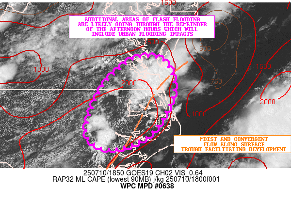
DISCUSSION...The latest GOES-E visible satellite imagery along
with dual-pol radar shows a southwest to northeast oriented axis
of heavy showers and thunderstorms impacting the greater Hampton
Roads area of southeast VA, with a gradual increase in convection
seen developing across northeast NC. The activity is developing
and expanding coverage along a surface trough which is driving
convergent low-level flow within a very moist and unstable
environment.

MLCAPE values of 2000 to 3000 J/kg are noted over eastern NC and
into far southeast VA, with PWs of 2.25+ inches. This has already
helped to contribute to rainfall rates of 2 to 3 inches/hour with
the stronger storms, and these rates should be maintained at least
through the remainder of the afternoon hours.

The latest HRRR/RRFS guidance suggests some additional rainfall
totals of 3 to 4+ inches where some of these cells locally train
over the same area. Additional areas of flash flooding are likely
given the setup this afternoon, and this will include some notable
urban flash flooding concerns around Hampton Roads area in
particular.

Orrison

ATTN...WFO...AKQ...MHX...RAH...

ATTN...RFC...ALR...RHA...NWC...

LAT...LON   37317653 37257589 36517565 35507620 35127712
            35487773 36477742 36997700
Download in GIS format: Shapefile
| KML
Last Updated: 305 PM EDT Thu Jul 10 2025
|


