| WPC Met Watch |
|
|
Mesoscale Precipitation Discussion: #0639 |
|
(Issued at 629 PM EDT Thu Jul 10 2025
) |
|
| MPD Selection |
|
|
|
|
|

Mesoscale Precipitation Discussion 0639
NWS Weather Prediction Center College Park MD
629 PM EDT Thu Jul 10 2025

Areas affected...Eastern Nebraska and Western Iowa

Concerning...Heavy rainfall...Flash flooding possible

Valid 102230Z - 110430Z

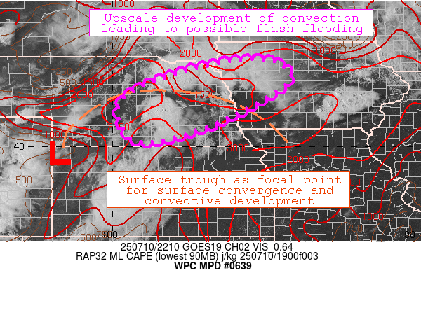
SUMMARY...Showers and thunderstorms initiating along a surface
trough across eastern Nebraska are growing upscale with some
backbuilding, leading to an increasing flash flood threat.

DISCUSSION...GOES-East satellite imagery indicates that the
earlier line of elevated convection that moved through
northeastern Nebraska left behind several hours of clearer skies,
leading to enough daytime heating to initiate a new round of
surface-based thunderstorms. A surface trough extending through
eastern Nebraska from a surface low centered near northwest Kansas
and southwest Nebraska is providing a zone of convergence that
will serve as a focal point for continued convective initiation.
MLCAPE values of 2000-3500 J/kg across the region, combined with
30-40 knots of 0-6 km Bulk Shear, supports the development of
severe convection. Convection should begin as scattered
thunderstorms with some isolated supercells, then steadily growing
upscale into an organized MCS later in the period as the
upper-level shortwave energy rotates through and the existing
convection across eastern Colorado and western Kansas eventually
merges with the convection over eastern Nebraska as a larger MCS.

Although the 850 mb low-level jet of 20-30 knots is relatively
weak, there is significant moisture convergence occurring along
the axis of the surface trough, with a 19Z sounding at LBF
indicating a PW of 1.27" which is close to the 90th percentile
relative to climatology. Combined with a deep-layer mean
southwesterly flow of only 20-25 knots, relatively slow storm
motions and propagation vectors into the weak low-level jet
suggests that backbuilding and upscale growth over the next few
hours will lead to an increased risk for flash flooding. CAMs
guidance is in good agreement with this flash flood potential,
with HREF probabilities at 50-70% of 3-hr QPF exceeding 2". Flash
flood guidance values also drop off significantly from west to
east across Nebraska, given the moist antecedent conditions across
eastern Nebraska and western Iowa, so FFG is less than 2" across
the area of concern.

Shieh

ATTN...WFO...DMX...FSD...GID...LBF...OAX...

ATTN...RFC...KRF...MSR...NWC...

LAT...LON   42909505 42259411 40979618 40269822 40269822
            40329939 41559969 42529753
Download in GIS format: Shapefile
| KML
Last Updated: 629 PM EDT Thu Jul 10 2025
|


