| WPC Met Watch |
|
|
Mesoscale Precipitation Discussion: #0641 |
|
(Issued at 943 PM EDT Thu Jul 10 2025
) |
|
| MPD Selection |
|
|
|
|
|

Mesoscale Precipitation Discussion 0641
NWS Weather Prediction Center College Park MD
943 PM EDT Thu Jul 10 2025

Areas affected...Eastern North Carolina

Concerning...Heavy rainfall...Flash flooding possible

Valid 110142Z - 110542Z

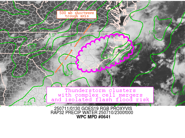
SUMMARY...Complex cell mergers associated with several clusters of
ongoing convection are contributing to the possibility of isolated
flash flooding.

DISCUSSION...Several clusters of convection are ongoing across
eastern North Carolina in an environment of weak deep-layer mean
flow of 10-15 knots out of the west-southwest. As a result,
erratic storm motions are being driven by the complex interactions
of mesoscale cold pools. Although peak daytime heating has passed,
MLCAPE is still in the 1500-2500 J/kg range. Furthermore, as the
500 mb shortwave trough axis rotates through, the convection is
likely to sustain itself for a few more hours.

The atmosphere is still extremely moist with the 00Z MHX sounding
indicating a PW value of 2.18", which exceeds the 90th percentile
relative to climatology. This pool of moisture across eastern
North Carolina and the Outer Banks is well represented by the CAMs
guidance, and HREF 3-hr QPF probabilities of exceeding 2" is
40-50% for the region, with probabilities of exceeding the 6-hour
flash flood guidance at 25-40%. These values suggest that although
the dynamics are not conducive for a sustained, widespread threat
of flash flooding, the slow storm motions, erratic cell mergers,
and high moisture content suggest that there is at least an
isolated flash flood risk.

Shieh

ATTN...WFO...AKQ...ILM...MHX...RAH...

ATTN...RFC...ALR...NWC...

LAT...LON   36277616 35197542 34117702 33717882 34167944
            35187911 35967786
Download in GIS format: Shapefile
| KML
Last Updated: 943 PM EDT Thu Jul 10 2025
|


