| WPC Met Watch |
|
|
Mesoscale Precipitation Discussion: #0642 |
|
(Issued at 1146 PM EDT Thu Jul 10 2025
) |
|
| MPD Selection |
|
|
|
|
|

Mesoscale Precipitation Discussion 0642
NWS Weather Prediction Center College Park MD
1146 PM EDT Thu Jul 10 2025

Areas affected...Northern Illinois...Southeast Iowa...Ext
Northwest IND...

Concerning...Heavy rainfall...Flash flooding likely

Valid 110345Z - 110930Z

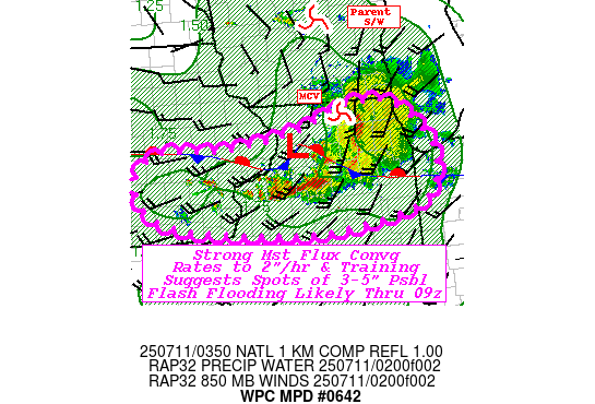
SUMMARY...Lead shortwave with flanking line development and
potential for repeating across areas of Northern IL through the
overnight hours.  Hourly rates to 2"/hr suggest 3-5" totals are
possible, resulting in likely incidents of flash flooding.

DISCUSSION...Regional RADAR mosaic depicts a mature MCS with
strengthening MCV over N IL  with moderate shield precipitation
straddling the IL/WI line.  A surface wave can be analyzed
southwest of RPJ with stationary front across NE IL into northern
IND, while the trailing boundary extends across into central IA.
GOES-E WV and RAP analysis shows the stronger parent shortwave is
located much further north across central WI; though a stronger
northern stream wave continues to organize upstream across the
Missouri River Valley.  As such, the combination is helping to
retain strong broad southerly LLJ providing WAA and deep moisture
convergence in proximity the surface boundary; winds are 20-25kts
at 850mb and remain confluent to the shortwave across WI.  As
such, solid convergence remains along the upstream flanking line
across NW IL with thunderstorms still cooling even as the
instability has be diminishing relative to upstream as well.
Downstream, even lower CAPE values toward NW IND shows the slow
erosion of the convective cells and warming tops.

CIRA LPW shows 850-700mb layer has been increasing (though recent
uptick is likely due to a particular over-estimate of values since
01-02z) but the pattern shows the flux to maintain near 2.0" total
PWat values to maintain rainfall efficiency to the convection.
Southwest to west-southwest instability flux will also support
back-building potentially across into E IA, though capping is a
tad stronger.  Still, redevelopment in NW IL with slow east to
east-southeast propagation will allow for tracks of repeating and
potential for multiple hours of 1.5-2"/hr rates.  Localized totals
of 3-5" are not out of the realm of possibility especially in
proximity to I-80.  Given FFG values of 1.5-2"/hr and 3hr
generally around 2-3"; a few incidents of flash flooding along the
line are considered likely.  Of particular concern, is upstream
development across NEB into central IA, that may intersect with
this area toward pre-dawn and will watch the evolution
closely...an upstream MPD will also be issued within the next hour
or so.

Gallina

ATTN...WFO...DMX...DVN...ILX...LOT...

ATTN...RFC...MSR...NWC...

LAT...LON   42428874 42408787 41958730 41478709 40898745
            40618904 40629034 40789204 41069279 41609294
            41929244 41899131 41979045 42059000 42168949
Download in GIS format: Shapefile
| KML
Last Updated: 1146 PM EDT Thu Jul 10 2025
|


