| WPC Met Watch |
|
|
Mesoscale Precipitation Discussion: #0649 |
|
(Issued at 554 PM EDT Fri Jul 11 2025
) |
|
| MPD Selection |
|
|
|
|
|

Mesoscale Precipitation Discussion 0649
NWS Weather Prediction Center College Park MD
554 PM EDT Fri Jul 11 2025

Areas affected...NM/CO border into the TX/OK Panhandles

Concerning...Heavy rainfall...Flash flooding possible

Valid 112154Z - 120354Z

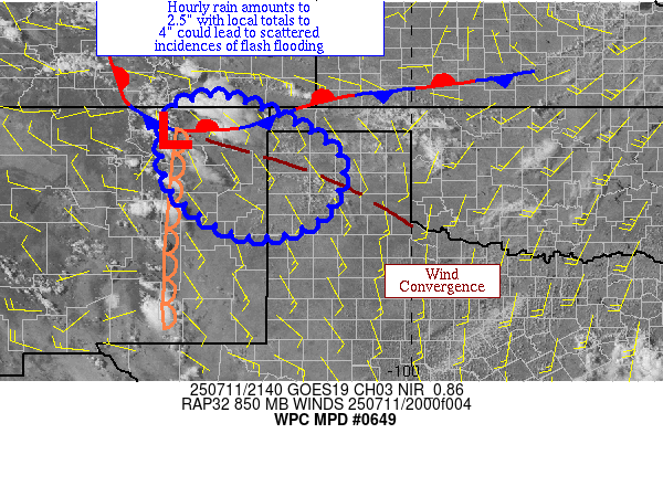
Summary...Thunderstorms near the CO/NM border are starting to
increase in number.  Hourly rain amounts to 2.5" and local totals
to 4" are possible, which could lead to scattered flash flood
concerns.

Discussion...Showers and thunderstorms are beginning to increase
in number near a front in the vicinity of the CO/NM border.
Precipitable water values of 0.75-1", ML CAPE of 500 j/kg inhabits
their neighborhood, with higher values lying to the east.
Effective bulk shear of 30-40 kts also lies in the vicinity, which
should organize the convective activity.

Increasing low-level inflow, moisture, and instability should lead
to a growing convective complex that moves into the TX Panhandle
with time.  The increasing moisture/instability may lead to a
fairly broad convective profile as any outflow boundaries from the
convective mass cause periods of new convective growth and
reorganization.  While the front itself appears to hang up, the
700 hPa thermal difluence indicates that a propagation to the
southeast or even south-southeast should be expected over time
should occur near and south of a zone of wind convergence apparent
in the 21z observations.  Both the 18z HREF and 12z RRFS show this
sort of propagation, which may be aided by new convection moving
near the dryline south of the front.  The moisture and instability
support hourly rain amounts to 2.5" and local totals to 4".  With
flash flood guidance being modest in the region, this could lead
to widely scattered to scattered flash flood concerns.

Roth

ATTN...WFO...ABQ...AMA...LUB...PUB...

ATTN...RFC...FWR...TUA...NWC...

LAT...LON   37160373 36010157 34650197 34300354 35160498
            36170525 37020498
Download in GIS format: Shapefile
| KML
Last Updated: 554 PM EDT Fri Jul 11 2025
|


