| WPC Met Watch |
|
|
Mesoscale Precipitation Discussion: #0650 |
|
(Issued at 620 PM EDT Fri Jul 11 2025
) |
|
| MPD Selection |
|
|
|
|
|

Mesoscale Precipitation Discussion 0650
NWS Weather Prediction Center College Park MD
620 PM EDT Fri Jul 11 2025

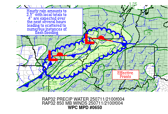
Areas affected...portions of the Upper Midwest

Concerning...Heavy rainfall...Flash flooding likely

Valid 112219Z - 120419Z

Summary...An incoming convective line with preceding thunderstorms
is expected to lead to cell mergers in the near term.  Hourly rain
amounts to 2.5" and local totals to 4" remain likely through 02z,
and possible thereafter.  Scattered to numerous areas of flash
flooding are anticipated.

Discussion...An MCV appears to be forming across northeast IA in
association with a broadening and maturing convective complex over
the Upper Midwest.  Precipitable water values are near 2".  ML
CAPE up to 3500 J/kg lies within the warm sector.  Effective bulk
shear of 30-45 kts is helping to organize the convective area.

In the near term, cell mergers between the incoming line and
preceding convection along with random mesocyclones are expected
to lead to hourly rain amounts to 2.5" with local amounts to 4"
until at least 02z.  Thereafter, a narrowing convective footprint
is expected as it reduces the instability pool currently in the
warm sector and the convective line winnows and picks up the pace.
 Still, random mesocyclones along the line after 02z could lead to
a LWEP or QLCS structure for at least a couple more hours which
would lead to locally heavy rainfall.  Some portions of the region
-- particularly northern IL & portions of Chicago -- have seen
heavy rainfall recently, which has led to low flash flood
guidance.  Scattered to numerous flash flood events are expected
through 02z, even outside urban areas, before becoming more
scattered to widely scattered thereafter.

Roth

ATTN...WFO...ARX...DMX...DVN...EAX...ILX...LOT...LSX...MKX...

ATTN...RFC...KRF...MSR...NWC...

LAT...LON   43269062 43258926 42508784 41798763 40988958
            40029112 39239240 39059416 39729497 41109433
            41709295 42099149 42739114
Download in GIS format: Shapefile
| KML
Last Updated: 620 PM EDT Fri Jul 11 2025
|


