| WPC Met Watch |
|
|
Mesoscale Precipitation Discussion: #0652 |
|
(Issued at 758 PM EDT Fri Jul 11 2025
) |
|
| MPD Selection |
|
|
|
|
|

Mesoscale Precipitation Discussion 0652
NWS Weather Prediction Center College Park MD
758 PM EDT Fri Jul 11 2025

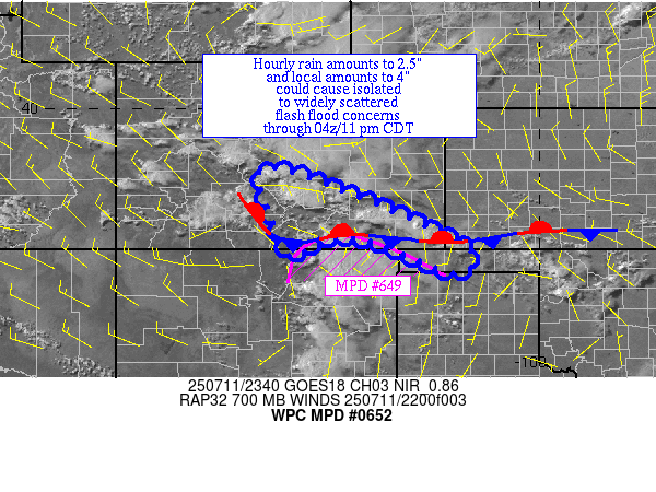
Areas affected...in and near portions of southeast CO

Concerning...Heavy rainfall...Flash flooding possible

Valid 112356Z - 120400Z

Summary...Thunderstorms with heavy rain are increasing in coverage
north of MPD #649.  Hourly rain amounts to 2.5" and local amounts
to 4" are possible.

Discussion...Thunderstorms with heavy rain have been developing
west and south of Pueblo CO near a stalling front and moving
little, sometimes chaotically, during their life cycle.
Precipitable water values are 0.75-1".  ML CAPE is 500-2000 J/kg
in their vicinity.  Effective bulk shear of ~35 kts lies in the
vicinity which could organize the convection.

Over the next few hours, these storms should have enough moisture
and instability to work with to persist.  Hourly rain amounts to
2.5" with local totals to 4" are possible.  The mesoscale guidance
(HREF and RRFS) show that convection this far north could persist
for another several hours.  Chose a valid time that matches MPD
#649 when the broader situation in this portion of the High Plains
can be reevaluated.

Roth

ATTN...WFO...ABQ...AMA...BOU...DDC...PUB...

ATTN...RFC...FWR...TUA...NWC...

LAT...LON   38730583 37840324 36940146 36500189 37140344
            37260457 36860530 37670571
Download in GIS format: Shapefile
| KML
Last Updated: 758 PM EDT Fri Jul 11 2025
|


