| WPC Met Watch |
|
|
Mesoscale Precipitation Discussion: #0655 |
|
(Issued at 541 AM EDT Sat Jul 12 2025
) |
|
| MPD Selection |
|
|
|
|
|

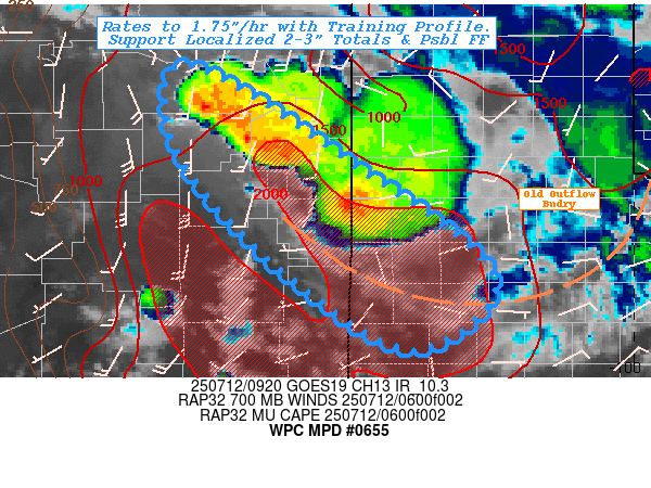
Mesoscale Precipitation Discussion 0655
NWS Weather Prediction Center College Park MD
541 AM EDT Sat Jul 12 2025

Areas affected...East-Central NM... Western Cap Rock/Northern
Permian Basin of West Texas...

Concerning...Heavy rainfall...Flash flooding possible

Valid 120940Z - 121500Z

SUMMARY...Elevated thunderstorms with training/repeating with
hourly rates of 1.5-1.75" and spotty 2-3" totals may pose
localized flash flooding through day break.

DISCUSSION...In the wake of the initial bowing convective complex
through the northern TX panhandle overnight, the southwestern
untapped flank has remained a corridor a enhanced 850-800mb
southeasterly moist return flow and providing a modest northwest
to southeast theta-E gradient.  As the MCS expanded, merged
growing upscale into the larger shortwave trough currently
centered over SW KS; return southerly 700mb flow intersected the
boundary with enhanced 1500-2000 J/kg MUCAPE due to steepened
mid-level lapse rates and ample remaining low level moisture.  The
15-20kts of fairly orthogonal isentropic ascent resulted in
elongated activation and expansion of elevated thunderstorm
clusters.  Given deeper level moisture in the 850mb layer, based
likely have lowered a bit and tapped greater moisture depth for
increasingly efficient rainfall.  Rates of 1.5-1.75" are becoming
common within the broadening cores; combine this with favorable
rear inflow jet orientation to the 700-400mb flow behind the dead
bowing segments has allowed for favorable repeating axis over the
next few hours.  With strongly veered/WAA flow from 850-700mb,
propagation vectors may deflect the overall clusters southward
from ideal training, but there should be ample opportunity for a
few locations to receive 2-3" in the next few hours.

Hydrologically, east-central NM remains slightly above average in
soil saturation especially from San Miguel/N Guadalupe,SW Quay,
Roosevelt toward Bailey/Cochran in the western Cap Rock.  Hourly
FFG values of 1-1.5" in the west toward 1.5-2"/hr eastward and 3hr
values generally from 1.5-3" are at some risk of localized
exceedance.  As such, an incident or two of flash flooding is
considered possible through the early morning hours/day-break

Gallina

ATTN...WFO...ABQ...LUB...MAF...

ATTN...RFC...FWR...TUA...NWC...

LAT...LON   35720476 34680306 33450151 32670235 33380359
            34380462 35160501
Download in GIS format: Shapefile
| KML
Last Updated: 541 AM EDT Sat Jul 12 2025
|


