| WPC Met Watch |
|
|
Mesoscale Precipitation Discussion: #0669 |
|
(Issued at 1228 PM EDT Sun Jul 13 2025
) |
|
| MPD Selection |
|
|
|
|
|

Mesoscale Precipitation Discussion 0669
NWS Weather Prediction Center College Park MD
1228 PM EDT Sun Jul 13 2025

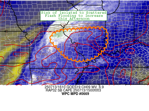
Areas affected...Eastern MO into central and southern IL

Concerning...Heavy rainfall...Flash flooding possible

Valid 131627Z - 132227Z

SUMMARY...Expanding convection will lead to an isolated to
scattered flash flood risk over portions of eastern Missouri into
central and southern Illinois this afternoon.

DISCUSSION...Troughing with an elongated area of vorticity
stretches from central OK into western IL, with some more
mesoscale MCV features likely embedded within. Latest radar and
satellite indicates one such feature currently moving across
central MO and possibly another near the AR/MO border...and these
will likely help drive an expansion of convection and at least
some flash flood risk as we head into the afternoon hours. The
initial focus will likely be near the MCV center over northeast
MO, and then extending eastward near the stationary front into
central IL. PWs are near 2", and the activity thus far is fairly
low topped (per IR imagery), and thus we are likely getting some
efficient warm rain processes. Given the slow cell motions near
the MCV and along the front...these cells could locally produce
upwards of 1-3" of rain per hour as convection intensifies over
the next couple hours.

Both the 12z HREF and 06z REFS show an uptick in the coverage of
1" per hour probabilities after 18z from eastern MO into
central/southern IL...with neighborhood probabilities over 60%
covering much of the MPD area. Two inch per hour probabilities are
lower, but still notable...around 40% in the HREF and as high as
80% in the REFS. Continued destabilization ahead of the trough/MCV
and broad upper level divergence will help drive this increase in
convective coverage after 18z. Deep layer mean flow is out of the
southwest around 20kts...so cells will be fairly quick moving.
However guidance indicates an increase in the low level jet as we
head through the afternoon...which acts to decrease upwind
propagation speeds, and turn the vectors more south to even
southwesterly. This suggests that as convection increases in
coverage and attempts to grow upscale this afternoon we could see
some backbuilding on the south to southwest flank of convection.
This potential training of convection should locally increase
rainfall magnitudes this afternoon...especially across central to
southern IL...where some areas will likely exceed 3". The
probability of exceeding 5" in both the HREF and REFS drops
significantly...likely due to the overall progressive nature of
the system. Thus generally expecting event total rain to peak in
the 2-4" range...with any 5" amounts staying localized. This
amount of rain should be enough to cause isolated to scattered
instances of flash flooding.

Chenard

ATTN...WFO...EAX...ILX...IND...LSX...PAH...SGF...

ATTN...RFC...KRF...MSR...ORN...TIR...NWC...

LAT...LON   40258848 40238782 39998747 38498762 37598865
            37408922 37319018 37699127 38429185 38929239
            39379263 39829223 40029154 40089071 40208958
Download in GIS format: Shapefile
| KML
Last Updated: 1228 PM EDT Sun Jul 13 2025
|


