| WPC Met Watch |
|
|
Mesoscale Precipitation Discussion: #0671 |
|
(Issued at 155 PM EDT Sun Jul 13 2025
) |
|
| MPD Selection |
|
|
|
|
|

Mesoscale Precipitation Discussion 0671
NWS Weather Prediction Center College Park MD
155 PM EDT Sun Jul 13 2025

Areas affected...Central Appalachians and Mid-Atlantic Piedmont

Concerning...Heavy rainfall...Flash flooding possible

Valid 131755Z - 132355Z

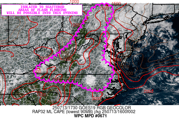
SUMMARY...Scattered showers and thunderstorms with very heavy
rainfall rates will continue to develop and expand in coverage.
Isolated to scattered areas of flash flooding will be possible
going through the afternoon and into the evening hours.

DISCUSSION...The latest GOES-E GeoColor RGB satellite imagery
shows convection continuing to initiate and expand in coverage
across portions of central NC through southwest and western VA.
There will be additional areas of heavy showers and thunderstorms
that will gradually develop further back across the central
Appalachians with an expansion generally north near and west of
the Blue Ridge including areas of eastern WV through western VA,
the MD/WV Panhandles and large areas of southwest and central PA.

Given strong diurnal heating near and adjacent to the terrain,
MLCAPE values have increased to 1000 to 2000+ J/kg. Meanwhile, the
column is very moist with the 12Z IAD RAOB showing a 2.14" PW and
and a tall skinny CAPE profile that is strongly suggestive of
warm/tropical rain processes. This will support enhanced rainfall
rates with any thunderstorm activity this afternoon and this
evening.

Terrain-driven circulations/orographics and differential heating
boundaries will tend to support a substantial amount of terrain
focused convection over the next several hours given the level of
moisture and instability in the column, but areas farther east
over the Piedmont may also see convection become locally more
expansive by later this afternoon. This will includes areas of
central NC around the Raleigh-Durham area where a cluster of
storms is noted just east of the city.

Rainfall rates will be capable of reaching 2 to 3 inches/hour with
the stronger storms, and with slow cell-motions, some spotty storm
totals of 3 to 4+ inches will be possible by this evening. This is
consistent with some of the 12Z HREF guidance.

Isolated to scattered areas of flash flooding will be possible,
and this will include areas of locally rugged terrain near the
central Appalachians/Blue Ridge and also around any urbanized
corridor that sees convection.

Orrison

ATTN...WFO...AKQ...BGM...CTP...GSP...LWX...MHX...MRX...PBZ...
RAH...RLX...RNK...

ATTN...RFC...ALR...ORN...RHA...TIR...NWC...

LAT...LON   41977730 41677671 39997736 39247725 38537739
            37677744 36937667 35517739 35517855 36037966
            36088062 36298229 37008256 38068089 39397954
            40887868 41767804
Download in GIS format: Shapefile
| KML
Last Updated: 155 PM EDT Sun Jul 13 2025
|


