| WPC Met Watch |
|
|
Mesoscale Precipitation Discussion: #0674 (2023) |
|
(Issued at 1104 AM EDT Sun Jul 09 2023
) |
|
| MPD Selection |
|
|
|
|
|

Mesoscale Precipitation Discussion 0674
NWS Weather Prediction Center College Park MD
1104 AM EDT Sun Jul 09 2023

Areas affected...Interior Northeast

Concerning...Heavy rainfall...Flash flooding likely

Valid 091505Z - 092100Z

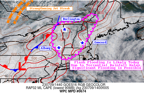
SUMMARY...An increasingly unstable and highly saturated atmosphere
will give rise to widespread thunderstorms today. Flash flooding
is likely and could become significant, particularly in areas with
highly saturated soils.

DISCUSSION...Similar to their neighbors in MPD 674, a robust
250-500mb trough axis near the central Appalachians will work in
tandem with a strengthening jet streak to the northwest to
generate strong vertical ascent within the atmospheric column. The
region lies beneath the divergent right-entrance region of the jet
streak, while a near by stationary front and surface based heating
spark numerous thunderstorms this afternoon. The atmosphere is
already supportive of convection to develop in short order. RAP
mesoanalysis already shows >1,000 J/kg of MLCAPE in the Hudson
Valley and as far north as Lake Champlain. With the aid of surface
based heating and low level moisture advection, MLCAPE should rise
to >1,500 J/kg this afternoon. RAP forecasts show PWATs rising to
1.5-1.75" by mid-afternoon, values that eclipse the 90th
climatological percentile according to NAEFS.

As winds strengthen aloft and storms form, atmospheric profiles
will grow highly saturated. 1000-500mb RH values are forecast to
rise above 90%, especially in the southern half of the highlighted
region this afternoon. Sampled RAP soundings in northern NY,
central VT, and central NH around 21Z all show roughly the same
thing-- highly saturated, skinny CAPE profiles, and warm cloud
layers as deep as 10,000-12,000ft deep. Hodographs in the area
show increasingly sheared soundings this afternoon (thanks to
increasing speed shear with height), but winds will be primarily
out of the SW. Some RAP soundings show Corfidi upshear vectors as
low as 10 knots, suggesting the potential for backbuilding
convection that can be aided by persistent upslope flow in
topographically-favored locations.

Not only is the atmosphere primed to produce Excessive Rainfall
rates, but most soils are highly saturated from the past 7-days
worth of rainfall. AHPS 7-day rainfall shows totals in southern
NH/VT that are 300-400% of normal, with much of the Lower Hudson
Valley and the Adirondacks seeing similar amounts. Some of these
areas, most notably south-central VT, have already dealt with
washed out roads and culverts from the heavy rainfall on July 7.
These atmospheric parameters, along with the sensitive soils in
place, will likely result in flash flooding this afternoon. Hourly
rainfall rates are likely to range between 2-3"/hr in the most
intense thunderstorm activity. Water will have the potential to
rise rapidly in poor drainage areas, in urbanized communities, and
may even result in mudslides in steep terrain.

Mullinax

ATTN...WFO...ALY...BOX...BTV...GYX...

ATTN...RFC...NERFC...NWC...

LAT...LON   45897075 45577011 43407129 42197208 41727326
            41917363 42417373 43057429 43977431 45017388
            45327162
Last Updated: 1104 AM EDT Sun Jul 09 2023
|


