| WPC Met Watch |
|
|
Mesoscale Precipitation Discussion: #0706 (2022) |
|
(Issued at 553 AM EDT Mon Aug 08 2022
) |
|
| MPD Selection |
|
|
|
|
|

Mesoscale Precipitation Discussion 0706
NWS Weather Prediction Center College Park MD
553 AM EDT Mon Aug 08 2022

Areas affected...Northern IL

Concerning...Heavy rainfall...Flash flooding likely

Valid 080953Z - 081330Z

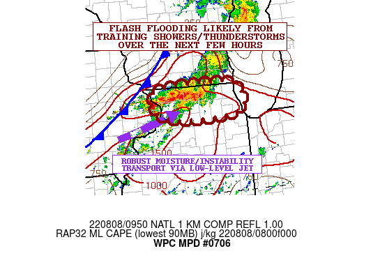
SUMMARY...An axis of training showers and thunderstorms with
extremely heavy rainfall rates will be crossing through northern
IL this morning. Flash flooding will be likely and this will
include impacts to the Chicago metropolitan area and especially
the western and northern suburbs of the downtown area.

DISCUSSION...The latest radar imagery shows an axis of very heavy
showers and thunderstorms advancing generally east across
northwest to north-central IL and along the IL/WI border. Over the
last hour, the convection has been attaining better organization
and this is evidenced by GOES-East IR satellite imagery showing an
expansion of very cold convective tops.

Facilitating the increased coverage and organization of convection
over the last couple of hours has been the arrival of a low-level
jet of 30+ kts out ahead of a cold front advancing gradually
southeast across the Midwest and in association with the passage
of a mid-level trough over the upper Great Lakes region. This
low-level jet has been instrumental in driving robust moisture and
instability transport northeastward across northern IL along an
axis of stronger low-level convergence associated with a remnant
outflow boundary that has been retreating back to the north.

The moisture profile across the region is very impressive with PWs
of 2.0 to 2.25 inches, and this coupled with MLCAPE values of
1500+ j/kg should encourage locally extreme rainfall rates that
may reach 2.5 to 3 inches/hour. Some of the recent MRMS data
indicates just that across parts of northwest IL where some of the
deepest convection is noted.

Over the next few hours, the convection should advance generally
eastward across northern IL and along the WI/IL border with a
period of training cells expected. Some localized backbuilding of
cells may tend to maintain the convective threat going through at
least 12Z given the southwest low-level jet energy persisting
ahead of the cold front. Expect locally as much as 3 to 5 inches
of rain to fall with this band of showers and thunderstorms going
through dawn.

Areas of flash flooding are already occurring over parts of
northwest IL, and the downstream areas of north-central to
northeast IL including the greater Chicago metropolitan area may
experience some rather significant urban flooding impacts heading
into the Monday morning rush hour.

Orrison

ATTN...WFO...DVN...LOT...MKX...

ATTN...RFC...NCRFC...NWC...

LAT...LON   42558904 42488782 41998756 41778800 41758957
            41949027 42289038 42489013
Last Updated: 553 AM EDT Mon Aug 08 2022
|


