| WPC Met Watch |
|
|
Mesoscale Precipitation Discussion: #0717 |
|
(Issued at 1008 PM EDT Wed Jul 16 2025
) |
|
| MPD Selection |
|
|
|
|
|

Mesoscale Precipitation Discussion 0717
NWS Weather Prediction Center College Park MD
1008 PM EDT Wed Jul 16 2025

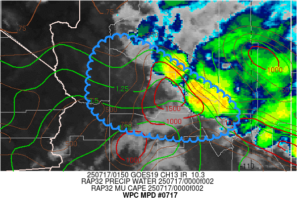
Areas affected...Central Arizona...

Concerning...Heavy rainfall...Flash flooding possible

Valid 170210Z - 170800Z

SUMMARY...Additional broader convective development expected as
outflows intersect seeking out remaining unstable air across the
Mogollon Rim Region.  Sub-hourly to hourly totals of 1.5-2" and
widely scattered flash flooding remain possible.

DISCUSSION...Inintial scattered thunderstorms along the southern
San Francisco Plateau have developed numerous outflow boundaries
that continue to press southwest into the the remaining pool of
MLCAPEs across west-central AZ into Yavapai and northern LaPaz and
Maricopa county.  CAPE of 500-1000 J/kg remains within favorably
intersecting southern inflow and into the deeper gradient (as
cloud bases drop coming over the Rim), increased moisture flux
convergence should increase into the bases of the clouds and
across new slab ascent along/ahead of the convergent outflow
boundaries.

Aloft, strong anticyclonic outflow across the northwestern edge of
the larger scale ridge into a 35-40kt 3H speed max across the Four
Corners, supports solid evactuation to support updraft stregth,
yet weaker 700-500mb flow allows for updrafts cells to back-shear
and remain relatively stationary for downdrafts to support 1.5-2"
focused totals in 30-60 minutes.  Given hard/rocky ground cover
most becomes runoff and as the updrafts broaden with potential
slab ascent, could intersect adjoining arrayos and dry washes for
continued widely scattered incidents of flash flooding possible
until the pool of instability is fully exhausted in the next few
hours.

Gallina

ATTN...WFO...FGZ...PSR...VEF...

ATTN...RFC...STR...NWC...

LAT...LON   35791308 35591246 35171181 34221045 33641052
            33421148 33681311 34171375 34801380 35541361
Download in GIS format: Shapefile
| KML
Last Updated: 1008 PM EDT Wed Jul 16 2025
|


