| WPC Met Watch |
|
|
Mesoscale Precipitation Discussion: #0719 |
|
(Issued at 1119 PM EDT Wed Jul 16 2025
) |
|
| MPD Selection |
|
|
|
|
|

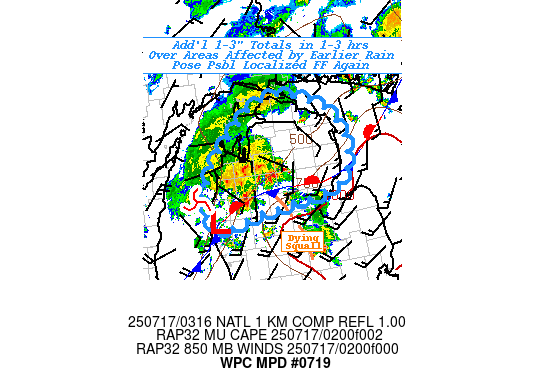
Mesoscale Precipitation Discussion 0719
NWS Weather Prediction Center College Park MD
1119 PM EDT Wed Jul 16 2025

Areas affected...Northern Lower Peninsula of Michigan...

Concerning...Heavy rainfall...Flash flooding possible

Valid 170320Z - 170830Z

SUMMARY...Potential of reaggrivating flooding conditions with
additional 1-3" as core of shortwave moves across areas having
locally received 3-5".  Additional flash flooding remains possible
through the overnight period.

DISCUSSION...GOES-E WV suite depicts a strong southern stream
shortwave in northern Lake Michigan with excellent outflow
depicted by baroclinic leaf of cirrus downstream into central
Ontario; but racing ahead of stronger, faster moving northern
stream wave in MN.   RADAR and surface observations show the
reflection of the deeply stacked wave just entering NW LP of MI
with well defined curved features, banding and downshear
precipitation shield with a few remaining embedded convective
elements within it.  Well defined stationary front with nearly 90
degrees of convergence and isentropic ascent along/ahead of dying
squall line across centra LP, veers slightly toward southwesterly
ascent but still very strong convergence/isentropic ascent across
the boundary.

Initial round mixed the atmosphere fairly well but there is some
remaining 500-1000 J/kg of MUCAPE in proximity to the best ascent
and given strong flux convergence ahead of the deep wave; cells
capable of 1.5"/hr rates within the broader .5-.75" precip shield
still may result in localized 1-3" totals given training profile.
This alone is not likely to result in localized flash flooding
conditions; however, given a broad swath received 3-5" totals with
some flooding seen earlier, the additional bout may still result
in additional flash flooding or at least some spots of
reaggravation of flooded rivers/streams.  As such, flash flooding
is considered possible along/ahead of the wave as it crosses the
northern LP.

Gallina

ATTN...WFO...APX...GRR...

ATTN...RFC...MSR...NWC...

LAT...LON   45788459 45588375 45278331 44648310 44138354
            43888522 43678636 44168651 44718632 45098592
            45588528
Download in GIS format: Shapefile
| KML
Last Updated: 1119 PM EDT Wed Jul 16 2025
|


