| WPC Met Watch |
|
|
Mesoscale Precipitation Discussion: #0720 |
|
(Issued at 1201 AM EDT Thu Jul 17 2025
) |
|
| MPD Selection |
|
|
|
|
|

Mesoscale Precipitation Discussion 0720
NWS Weather Prediction Center College Park MD
1201 AM EDT Thu Jul 17 2025

Areas affected...Central & Southeast PA...Maryland...DC...Northern
and Northwest VA...Northern DE...Far Soutwest NJ...

Concerning...Heavy rainfall...Flash flooding possible

Valid 170400Z - 170900Z

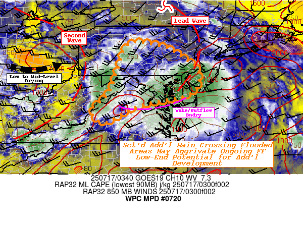
SUMMARY...Larger scale conditions improving, but scattered strong
cells along secondary squall line may cross already/currently
flooding areas and very low FFGs with additional quick 1-2"
sub-hourly total with another round of possible localized flash
flooding.

DISCUSSION...GOES-E WV and 500mb analysis shows a stack of phasing
shortwave centers from the northern most rapidly progressing
across MN, a second crossing the LP of MI and the third leading
southern stream wave still amplifying over Upstate NY.  The lead
wave resulted in strong thunderstorms that left many locations
across the Mid-Atlantic with high rates and totals with scattered
flash flooding with MRMS Crest unit Stream flows dotted across the
region still over 200-500 cfs/smi with greatest concentration from
Wilmington DE across the Capitol District into northern VA.   Most
cells have weakened with reduced convergence and loss of
instability but lingering into the Delmarva.

The second wave has stronger, more progressive height falls with
strong 850-700mb effective cold front pressing in a much drier low
to mid-level air mass out of the Ohio Valley. Still, strong
southerly (though has not really backed much still affected by the
leading wave) maintains solid moisture flux with well above
average moisture values of 2-2.25" advected northward into far
southeast PA/NJ and Maryland, but remains connected across the VA
Piedmont region.  A core of moisture near the effective triple
point to this wave is over-topping the Allegheny Plateau into
central PA providing a bit further moisture flux convergence with
about 30-40 degrees and 30-40kts of convergence to maintain
scattered stronger cells along the line.  GOES 10.3um shows tops
are generally warming, but still a few isolated overshooting tops
dot through the line.  Cells are progressive and rates are
reducing; which is to be expected with loss of day time heating
and mixing from initial round. But an additional quick burst of 1"
in a sub-hourly manner over flooded areas remains a problem for
reaggrivation of flooded rivers, creeks and roads in the area
still flooded from the first round.  So while coverage and
magnitude of flash flooding is likely to be lower end, the risk
remains for the next few hours.

Much of the central VA Piedmont missed out from the initial round,
this has left an area of untapped conditionally unstable air that
has advected northward in the wake of the initial cells along the
eastern slopes of the Blue Ridge into Northern VA/MD.  A weak east
to west outflow boundary does exist across northern VA into far
southern MD; a few Hi-Res CAM guidance members suggest moisture
flux convergence and isentropic ascent over this boundary may
trigger additional newer/stronger cells that may orient along the
boundary for some repeating training in proximity of areas
affected earlier tonight in N VA, DC and central MD.  Given this
risk, the MPD is expanded across this region on a low confidence
potential for additional 2-3" totals.

Gallina

ATTN...WFO...CTP...LWX...PHI...RNK...

ATTN...RFC...RHA...NWC...

LAT...LON   41197820 41097680 40647588 40337544 40017504
            39467497 38927528 38697606 38627648 38287793
            37797882 37557948 38137990 38887912 40037869
Download in GIS format: Shapefile
| KML
Last Updated: 1201 AM EDT Thu Jul 17 2025
|


