| WPC Met Watch |
|
|
Mesoscale Precipitation Discussion: #0730 (2018) |
|
(Issued at 405 PM EDT Tue Aug 28 2018
) |
|
| MPD Selection |
|
|
|
|
|

Mesoscale Precipitation Discussion 0730
NWS Weather Prediction Center College Park MD
405 PM EDT Tue Aug 28 2018

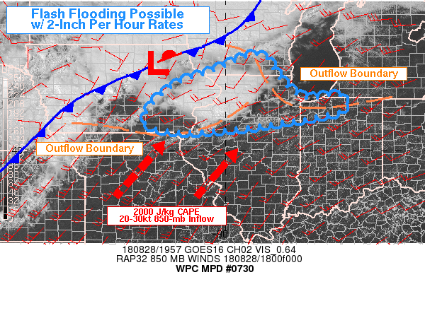
Areas affected...SE IA...WRN IL...NRN IN...SRN WI

Concerning...Heavy rainfall...Flash flooding possible

Valid 282004Z - 290004Z

Summary...A convective cluster over western Illinois will drift
east near an outflow boundary. Upstream forcing will arrive
through eastern Iowa by evening. Cell mergers and/or repeated
activity will lead to quick local 2 to 3 inch rainfall and
possible flash flooding.

Discussion...The synoptic environment was very favorable for heavy
rainfall across northern Iowa and central Wisconsin. Farther south
a zone of subtle warm advection had led to the gradual development
of a small MCS / cluster of storms over western Illinois near 20Z.
Entering the most deeply mixed portion of the afternoon, moderate
instability had become uncapped per the SPC mesoanalysis across
across eastern Missouri and much of Illinois. Steady, moderate
southwesterly  low level flow should provide sufficient inflow for
this weakly forced convection to persist. The 12Z WRF-ARW and NSSL
WRF had actually forecast this quite well to this point in time,
whereas the HRRR was not handling it well. This convective
cluster, whose health was somewhat dependent on its cold pool, may
persist a bit longer than even the ARW and NSSL WRF suggest - as
they dissipate the MCS toward 00Z, but all the lower Great Lakes
region will be marked by sufficient instability, inflow, and
increasingly deep synoptic lift ahead of the approaching frontal
system.

Precipitable water values, even in the pre-storm environment, were
near 1.90 to 2.00 inches. Reports of rapid accumulation of 2.50
inches of rain had already been seen out of Moline, IL, where
cells were beginning to merge to form the MCS. While Flash Flood
Guidance values were relatively high, this weather event will be
capable of exceeding the 2 inch / 1 hour or 3 inch / 3 hour
FFG...via both cell mergers in a highly efficient environment, and
perhaps repeated activity / training as cell motions and upstream
forcing appeared favorable for a several hour period of
pseudo-organized heavy rainfall.

Burke

ATTN...WFO...ARX...DMX...DVN...ILX...IWX...LOT...MKX...

ATTN...RFC...NCRFC...OHRFC...

LAT...LON   43158876 42488828 42078792 41708729 41878631
            41558599 41258652 40778951 40669168 41039267
            42099180 42669031 43058946
Last Updated: 405 PM EDT Tue Aug 28 2018
|


