| WPC Met Watch |
|
|
Mesoscale Precipitation Discussion: #0734 (2022) |
|
(Issued at 806 PM EDT Fri Aug 12 2022
) |
|
| MPD Selection |
|
|
|
|
|

Mesoscale Precipitation Discussion 0734
NWS Weather Prediction Center College Park MD
806 PM EDT Fri Aug 12 2022

Areas affected...Much of AZ...Far Southwestern NM...Far
Southeastern UT...Southeastern NV...Southeastern CA

Concerning...Heavy rainfall...Flash flooding likely

Valid 130000Z - 130600Z

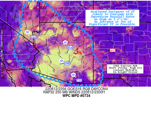
Summary...Scattered instances of flash flooding (some potnetially
significant) are likely to continue with rainfall rates as high as
1-2"+/hr. Showers and thunderstorms are expected to gradually
taper off to isolated coverage (and weaken) by late evening.

Discussion...Overall convective coverage has probably already
peaked across the Southwest late this afternoon, but scattered
showers and thunderstorms are likely to continue for at least a
couple more hours (before gradually becoming isolated late this
evening). Multi cell clusters have mostly concluded along the
Mogollon Rim, now gradually expanding northeast and southwest
towards higher and lower terrain, respectively. The stronger
convection has certainly occurred towards the southwest, with some
of the most impressive rain rates (1-2"+/hr) recently occurring
around the Phoenix Metro. The mesoscale environment to the south
and west of the Mogollon Rim is characterized by SB CAPE of
1000-3000 J/kg, highly anomalous precipitable water (PW) values of
1.5-2.0 inches (near daily record highs in the SPC climatological
sounding database at VEF, FLG, and PHX, and near the 90th
percentile at TUS), and effective bulk shear as high as 20 kts.
This is in stark contrast to the environment to the northeast,
where instability, moisture, and shear are all much lower (given
the placement of the upper-level ridge nearly directly overhead).
GOES day convection RGB shows this contrast quite well, with
brighter yellows indicating a much higher proportion of strong
updrafts across south-central and northwestern AZ into southern
NV.

Given the aforementioned favorable environment for additional
heavy rainfall, scattered convective coverage will probably
continue for 2-3 more hours (triggered primarily by outflow from
ongoing multi cell clusters and locally enhanced uplift from the
generation of an MCV). Coverage will gradually become isolated
late this evening as instability wanes, and hi-res CAMs are
generally in good agreement with this depiction (though it is
largely underdone relative to observational trends). Impressive
rainfall rates of 1-2"+/hr will primarily drive the flash flood
threat, with an instance or two of significant flash flooding
possible. Locations in the vicinity of the most sensitive terrain
features (burn scars, slot canyons, and normally dry washes)
should be on especially high alert for any potentially significant
flash flooding.

Churchill

ATTN...WFO...ABQ...EPZ...FGZ...LKN...PSR...SGX...SLC...TWC...
VEF...

ATTN...RFC...CBRFC...CNRFC...WGRFC...NWC...

LAT...LON   38931466 38671344 37901266 37031161 36631073
            36151008 35500940 34860933 34140920 32940851
            31970833 31590844 31280856 31230922 31251073
            31501165 31711250 31961336 32321443 32691509
            33251567 34041627 34781628 35541592 36141579
            36861565 37731555 38541535
Last Updated: 806 PM EDT Fri Aug 12 2022
|


