| WPC Met Watch |
|
|
Mesoscale Precipitation Discussion: #0741 (2020) |
|
(Issued at 745 AM EDT Sat Sep 12 2020
) |
|
| MPD Selection |
|
|
|
|
|

Mesoscale Precipitation Discussion 0741
NWS Weather Prediction Center College Park MD
745 AM EDT Sat Sep 12 2020

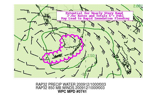
Areas affected...Florida Keys and Ext. Southern Peninsular
Florida...

Concerning...Heavy rainfall...Flash flooding possible

Valid 121145Z - 121745Z

SUMMARY...Tropical Depression 19L relatively stationary southeast
band.

DISCUSSION...Current GOES-E satellite and regional RADAR trends
continue to depict TD 19 developing as the circulation begins to
roll southwestward within the parent wave through Florida Bay.
This is enhanced by diurnal enhancement of offshore convective
development particularly along the SE quadrant of the circulation
which is generally aligned with the chain of the Florida Keys.
CIRA LPW loops show with this vortex roll up increased moisture
flux convergence through a solid vertical depth (tilted ever so
slightly toward the SE) currently focused at the apex of the
Florida Bay and Key Largo.   This is accounting for over 2.5" of
total precipitable water but with solid directional flux
convergence, there has been recent uptick in convective activity
along and southeast of the Keys with a new band of shallower
convection forming on the inside as well.  While instability is
limited to about 500-750 J/kg given deep moist adiabatic lapse
rates, it is sufficient to develop deep convection to -70C and
-80C tops with some lightning present.  Given this and the flux,
hourly rain rates of 2.5-3"/hr are likely with higher sub-hourly
rates likely.   While the Keys do not flash flood per se, the
intense rate will lead to inundation flooding particularly along
culverts and streets enough to be hazardous.  The uncertainty is
as it is always in the thunderstorms being able to pinpoint the
narrow strips that are the Keys.

Hi-Res CAMs including the rapidly refreshing RAP, HRRR and HRRRv4
all generally strong in depicting the development of the outside
(southeast) rainband.  Given the westward, maybe south of due
westward in the development phase of the surface circulation to
the natural flow along the SW FL coast, there is strong signal
from nearly all (particularly the HRRR, 00z ARW2 to have the band
set up close enough to the islands with persistent rates for
pockets of 4-6" with some suggestion of even higher totals to 8"
through 18z.  Normally, this kind of consensus and rainfall
rate/total would yield likely flash flooding conditions; however,
as mentioned above, the nature of flash flooding in the Keys as
well as the precision of hitting such a small target.

Gallina

ATTN...WFO...KEY...MFL...

ATTN...RFC...SERFC...NWC...

LAT...LON   25728092 25678048 25418024 24898040 24508129
            24388186 24418216 24648230 24748192 24878147
            25028127 25388126 25618129
Last Updated: 745 AM EDT Sat Sep 12 2020
|


