| WPC Met Watch |
|
|
Mesoscale Precipitation Discussion: #0744 (2018) |
|
(Issued at 115 AM EDT Sun Sep 02 2018
) |
|
| MPD Selection |
|
|
|
|
|

Mesoscale Precipitation Discussion 0744
NWS Weather Prediction Center College Park MD
115 AM EDT Sun Sep 02 2018

Areas affected...Central/Eastern IA...Northern IL...Southern WI

Concerning...Heavy rainfall...Flash flooding likely

Valid 020515Z - 020930Z

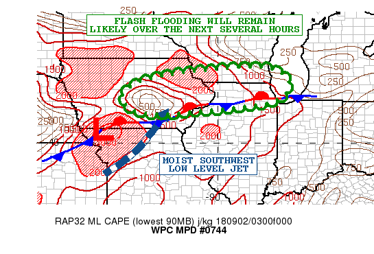
Summary...Multiple rounds of heavy showers and thunderstorms will
continue to focus across the Upper Midwest overnight. Flash
flooding will remain likely.

Discussion...The latest GOES-16 IR satellite imagery depicts an
extensive axis of cold-topped convection extending across the
Upper Midwest, including a large area of IA and northern IL. The
activity includes multiple repeating rounds of heavy showers and
thunderstorms which are focusing along and north of a
quasi-stationary frontal zone. This boundary is being convectively
reinforced, and the latest RAP analysis shows the best instability
pooled from south-central IA east into west-central IL, with
MLCAPE values of as much as 2000 to 3000 j/kg.

The convective potential should linger for a few more hours moving
past 06Z as there will be a low-amplitude shortwave over the
central Plains advancing east into western IA which will tend to
focus a weak wave of low pressure along the aforementioned front.
Warm advection ahead of this will focus a moist 30 to 35 kt
southwest low level jet over the boundary, and with the
aforementioned instability axis, the convection should remain
sustainable and also be capable of repeating over the same area.

The 00Z HREF guidance is not necessarily handling the activity
well, and appears to definitely be underplaying the rainfall
potential over areas of northern IL and southern WI. Based on the
latest satellite and radar trends, and high PWATS which are
pushing above 1.75 inches, expect rainfall rates of as much as 2
inches/hr, and additional totals of as much as 3 to 4 inches going
through 09Z. Will continue to monitor.

Orrison

ATTN...WFO...ARX...DMX...DVN...LOT...MKX...

ATTN...RFC...NCRFC...

LAT...LON   43128915 43088776 42598709 42078719 41708781
            41608829 41548896 41428969 41389034 41359080
            41229184 41239292 41379357 41819398 42199382
            42629299 42939115
Last Updated: 115 AM EDT Sun Sep 02 2018
|


