| WPC Met Watch |
|
|
Mesoscale Precipitation Discussion: #0747 (2018) |
|
(Issued at 601 PM EDT Sun Sep 02 2018
) |
|
| MPD Selection |
|
|
|
|
|

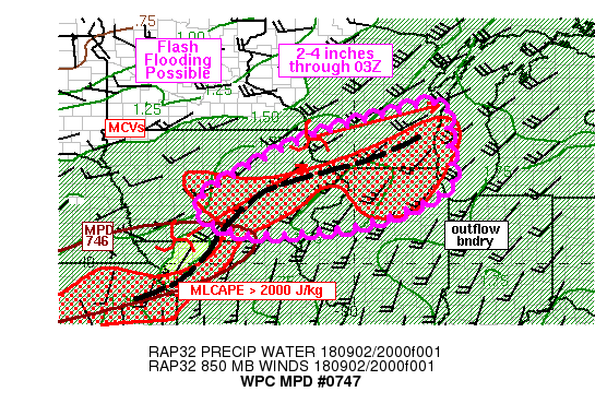
Mesoscale Precipitation Discussion 0747...Corrected
NWS Weather Prediction Center College Park MD
601 PM EDT Sun Sep 02 2018

Corrected for needed recreation of MPD graphic

Areas affected...eastern IA/southern WI/northern IL

Concerning...Heavy rainfall...Flash flooding possible

Valid 022138Z - 030325Z

Summary...Training and repeating rounds of heavy rain will cause a
threat for flash flooding from eastern IA into southern
WI/northern IL through 03Z. 2-4 inches of additional rainfall are
possible.

Discussion...Local radar imagery at 21Z showed two MCVs over IA,
one along the western IA/MO border and the other along the IA/WI
border, both moving toward the northeast. Each MCV was connected
to clusters of heavy rainfall with dual-pol estimated rain rates
of 1-2 in/hr within the heavier cores. Trends over the past hour
have shown convection filling in between the two MCVs over central
IA. The SPC mesoanalysis at 21Z depicted a sizable area of 2000+
J/kg MLCAPE just south of these MCVs.

While recent runs of the HRRR have struggled to capture the
magnitude of rainfall occurring over IA and WI, the idea of future
evolution is hinted at in its simulated reflectivity output. Both
MCVs are expected to continue a track off toward the
east-northeast while 25-30 kt 850 mb flow from the southwest
overruns a remnant outflow boundary enhanced by differential
heating. Given the 850-300 mb mean wind is roughly 20-30 kt (a
rough proxy for storm motions), some training/repeating of heavy
rain cores ie expected. In addition, diffluent flow aloft is
expected to enhance as an upper level jet to the north strengthens
through 03Z as forecast by the RAP. Flash Flood Guidance is rather
low over the region (1.5 to 2.5 inches in 3 hours) helping support
the threat for flash flooding with 2-4 inches of additional
rainfall possible through 03Z.

Otto

ATTN...WFO...ARX...DMX...DVN...GRB...ILX...LOT...MKX...

ATTN...RFC...MBRFC...NCRFC...

LAT...LON   44198771 43568760 42618746 42038752 41548841
            41058979 40809205 40859299 41199383 41769391
            43129147 43838924
Last Updated: 601 PM EDT Sun Sep 02 2018
|


