| WPC Met Watch |
|
|
Mesoscale Precipitation Discussion: #0751 (2020) |
|
(Issued at 1116 AM EDT Sun Sep 13 2020
) |
|
| MPD Selection |
|
|
|
|
|

Mesoscale Precipitation Discussion 0751
NWS Weather Prediction Center College Park MD
1116 AM EDT Sun Sep 13 2020

Areas affected...West-Central to Southwest Coast of Florida...

Concerning...Heavy rainfall...Flash flooding possible

Valid 131515Z - 132000Z

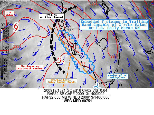
SUMMARY...Southwest band of T.S. Sally.

DISCUSSION...Tropical Storm Sally continues to move through the
northeast Gulf and away from Peninsular FL; however, the trailing
convergence band continues to reside in a favorable environment
for continued strong, highly efficient rainfall producing
thunderstorm environment.  The proximity to the coast of this band
remains the greatest uncertainty but there are ample signals to
suggest the threat remains high enough for the potential for
additional heavy rainfall and thunderstorms capable of 2-3"/hr
rates which could exacerbate ongoing flooding situations and lead
to rapid fresh water inundation flooding along the Southwest coast
of FL.  Currently, a weak mid-level shortwave and enhanced
surface/850mb wave exists along/near Sanibel island where strong
surface to 850mb confluence exist from Florida Bay to the
Southeast Gulf/Western Straits of Florida.  RAP analysis and 12z
KEY sounding support very narrow/skinny CAPE profile but with
solid surface warmth from the Gulf in the low 80s, supports
SBCAPEs of 3000-4000 J/kg, within the confluent flow region.
Strong thunderstorms exist along the surface to BL convergence
bands that are currently generally parallel to the coast up to
FMY, continued isentropic ascent north and east of this boundary
is providing moderate shield precip that continues to yield hourly
rates in the .25-.33" range, not much of a concern, and 3-6hr
totals of 1-2" are expected from Pinellas/Hillsborough to Sarasota
county.

However, nearer the triple-point of confluence greater onshore
surge of unstable air with embedded thunderstorms exists toward
Marco Island/Naples area.  Strong inflow upstream, will continue
to support backbuilding through this wedge over the next few hours
as the mid-level shortwave shears into the parent center toward
the north then northwest.   GOES-WV AMVs also suggest the
upper-level anticyclone is displaced over this area and southeast,
allowing for a 25-30kt outflow channel to form along/just west of
the West Coast of FL, to allow for greater outflow (and
surface/low level response for continued moisture flux
convergence.  As such, with 2.5-2.75" moisture values and flux of
35-40kts, thunderstorms in this wedge will have the capability of
4"/hr rates.  However, cell motions will lead to greater
transience of these rates back toward .5"/hr rates, though the
convergence band that generates them may be relatively stationary.
 Frictional convergence as cells cross, may allow for increased
upstream redevelopment in the wake of the initial cells to keep
some increased threat very near the coastline rather than 20-30
miles inland.  As such, spotty 3-5" totals may be expected from SW
Sarasota/Charlotte counties southward along the SW FL coastline
through W Collier county.  These rates may present possible rapid
onset fresh water inundation flooding as the tail end of the band
can start to propagate inland after the shortwave passage.

Gallina

ATTN...WFO...MFL...TBW...

ATTN...RFC...SERFC...NWC...

LAT...LON   27528269 27188224 26778193 25928130 25698133
            25748181 26248211 26668241 26958256 27318282
Last Updated: 1116 AM EDT Sun Sep 13 2020
|


