| WPC Met Watch |
|
|
Mesoscale Precipitation Discussion: #0751 (2023) |
|
(Issued at 743 PM EDT Sun Jul 16 2023
) |
|
| MPD Selection |
|
|
|
|
|

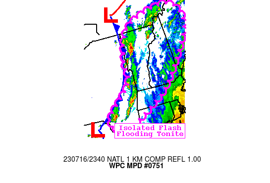
Mesoscale Precipitation Discussion 0751
NWS Weather Prediction Center College Park MD
743 PM EDT Sun Jul 16 2023

Areas affected...Interior New England and Middle Hudson Valley

Concerning...Heavy rainfall...Flash flooding possible

Valid 162342Z - 170530Z

SUMMARY...Continued shower and thunderstorm activity is expected
into the overnight. Highly sensitive soil conditions and elevated
stream flows from recent rainfall will promote isolated additional
instances of flash flooding through midnight.

DISCUSSION...Widely scattered showers and thunderstorms ahead of a
cold front have developed over eastern NY into VT early this
evening. The activity has generally developed parallel to the SWly
deep layer 30kt flow, allowing backbuilding and slow overall
motion.

Moderate instability with MUCAPE around 1500 J/kg should be
maintained by southwesterly flow ahead of the front and allow
redevelopment of this activity over interior sections of New
England and the middle Hudson Valley. PWs should remain around
1.8" which will promote further locally heavy rainfall. There is a
risk for activity to spread over areas along the central NH/Maine
border that saw 3-4" rainfall this afternoon and now have very
sensitive surface conditions. Orographics and upslope flow should
also remain a factor in where the heaviest rain sets up.

The thermodynamics should overcome nocturnal effects and allow
continued development of slow-moving showers and thunderstorms
that slowly progress east of the cold front. Rainfall rates will
continue to peak at 1-2"/hr where cells repeat most. Additional
localized storm total amounts of up to 3" are possible.

These additional rains will be falling over areas that are very
sensitive to additional rain given the very heavy rainfall totals
seen locally over the last week. Between saturated soil conditions
and elevated stream flows, these additional rains this evening
should continue to result in isolated additional flash flooding.

Jackson

ATTN...WFO...ALY...BGM...BOX...BTV...GYX...OKX...

ATTN...RFC...MARFC...NERFC...NWC...

LAT...LON   45647052 44676995 42747166 41947308 41427424
            41597478 41997495 43147354 44067343 45187276
Last Updated: 743 PM EDT Sun Jul 16 2023
|


