| WPC Met Watch |
|
|
Mesoscale Precipitation Discussion: #0755 (2020) |
|
(Issued at 1238 PM EDT Mon Sep 14 2020
) |
|
| MPD Selection |
|
|
|
|
|

Mesoscale Precipitation Discussion 0755
NWS Weather Prediction Center College Park MD
1238 PM EDT Mon Sep 14 2020

Areas affected...Eastern Florida Panhandle

Concerning...Heavy rainfall...Flash flooding possible

Valid 141547Z - 142030Z

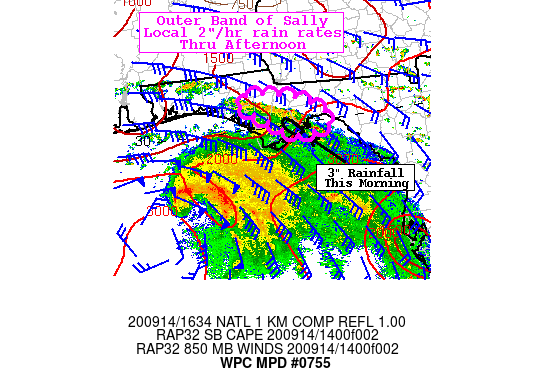
Summary...A narrow outer band of Sally will continue to spread
inland over eastern portions of the Florida Panhandle from
Apalachee Bay through the afternoon making for a heavy rainfall
and localized flash flooding threat.

Discussion...Three inches of rain have been estimated in northern
Franklin as well as southern Liberty and Calhoun counties on the
FL Panhandle from KTLH from a persistent outer band of Sally
spreading in from the Apalachee Bay. This band is drifting north
with southern Wakulla county now experiencing heavy rain. Ample
moisture is spreading in with the band with 2.3" PWs (about 2.5
standard deviations above normal) confirmed by GPS sensors. There
is an instability gradient along the shore with about 2500 J/kg
SBCAPE over the Apalachee Bay and 1500 J/kg over much of the FL
Panhandle which is contributing to diminishing rain rates as the
band shifts inland.

Rainfall of generally 1.5"/hr, but up to 2"/hr have been estimated
by KTLH and given the slow northward advancement, local areas have
received just about 3" which can be expected to continue going
forward this afternoon. Flash flood guidance is generally 3 to 4"
in 3 hours, so local exceedance of these guidance values is
possible through the rest of the afternoon as the band continues
to re-form and spread inland before slowing diminishing farther
inland (by about Washington and Jackson Co). Given the trajectory
and inflow from Apalachee Bay this band looks to remain south of
I-10 through the afternoon, but is expected to get into at least
southern portions of the Tallahassee metro where drainage issues
are anticipated.


Jackson

ATTN...WFO...TAE...

ATTN...RFC...SERFC...NWC...

LAT...LON   30598540 30518478 30268416 29988389 29858416
            29818459 30138520 30508571
Last Updated: 1238 PM EDT Mon Sep 14 2020
|


