| WPC Met Watch |
|
|
Mesoscale Precipitation Discussion: #0756 (2023) |
|
(Issued at 1215 PM EDT Tue Jul 18 2023
) |
|
| MPD Selection |
|
|
|
|
|

Mesoscale Precipitation Discussion 0756
NWS Weather Prediction Center College Park MD
1215 PM EDT Tue Jul 18 2023

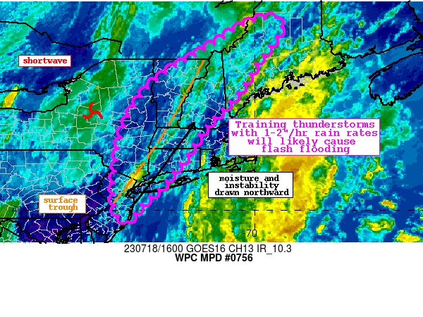
Areas affected...NJ, NY, Interior New England

Concerning...Heavy rainfall...Flash flooding likely

Valid 181614Z - 182200Z

Summary...Showers and thunderstorms will expand across the area
and train northeast through the evening. Rainfall rates of
1-2+"/hr could result in 2-3" of rain with locally higher amounts.
Flash flooding is likely.

Discussion...The regional radar mosaic this aftn shows rapidly
blossoming thunderstorms along a WPC analyzed surface trough from
near New York City (NYC) northeastward through western Maine. This
convection is expanding in response to ascent driven by the
low-level convergence along the trough aided by subtle PVA
downstream of a shortwave across Upstate NY and impressive upper
diffluence within the RRQ of a poleward arcing jet streak lifting
into Quebec. This deep-layer lift is occurring within extremely
favorable thermodynamics characterized by PWs of 1.3-1.5 inches as
measured by GPS, above the 75th percentile according to the SPC
sounding climatology, and a ribbon of SBCAPE above 2000 J/kg
surging across New England. Thunderstorms developing within this
environment have already produced radar-estimated rainfall rates
of 1.5-2"/hr, with mesonet observations of around 1 inch noted
west of NYC leading to CREST unit streamflow above 500 cfs/smi.

As the aftn progresses, convection is likely to expand in coverage
and intensify. The surface trough will advect only slowly eastward
in response to subtle height falls within the larger mid-level
trough. This will continue to drive low-level convergence for
ascent, aided by increasing upper diffluence as the jet streak
aloft intensifies and expands its tail southward. At the same
time, nearly unidirectional 850-300mb flow will remain parallel to
the trough and draw northward even more impressive PWs above 1.5
inches collocated with 2000 J/kg SBCAPE. This will result in an
impressive overlap of ascent and thermodynamics, and the high-res
models insist that convection will expand in coverage, with HREF
neighborhood probabilities suggesting a higher likelihood for
2"/hr rain rates. The HRRR indicates that 15-min rainfall could
even exceed 0.75 inches at times (brief 3+"/hr rates). With flow
parallel to the front driving aligned Corfidi vectors/mean winds,
this will result in echoes backbuilding into the higher
instability and then training northeastward, producing 2-3" of
rain with locally higher amounts along narrow axes.

This region has been exceptionally wet during the last 7 days as
noted by AHPS rainfall departures that are almost uniformly above
300% of normal resulting in USGS streamflow anomalies that are
nearing record highs. This has led to extremely compromised FFG
that is 0.75-1.5"/3hrs which has an HREF progged exceedance
probability of 15-35%. Where these intense rain rates train atop
the most vulnerable soils within sensitive terrain, or atop less
permeable urban areas, instances of flash flooding are likely.


Weiss

ATTN...WFO...ALY...BGM...BOX...BTV...CAR...GYX...OKX...PHI...

ATTN...RFC...MARFC...NERFC...NWC...

LAT...LON   46376921 45886922 44876996 43947054 42817159
            41807229 40947296 40217372 39757412 39627434
            39937456 40457465 41227460 42307444 43307405
            44357318 45347160 45517131 46197024
Last Updated: 1215 PM EDT Tue Jul 18 2023
|


