| WPC Met Watch |
|
|
Mesoscale Precipitation Discussion: #0757 (2018) |
|
(Issued at 1105 PM EDT Mon Sep 03 2018
) |
|
| MPD Selection |
|
|
|
|
|

Mesoscale Precipitation Discussion 0757
NWS Weather Prediction Center College Park MD
1105 PM EDT Mon Sep 03 2018

Areas affected...Northeast IA...Central/Southern WI

Concerning...Heavy rainfall...Flash flooding possible

Valid 040305Z - 040805Z

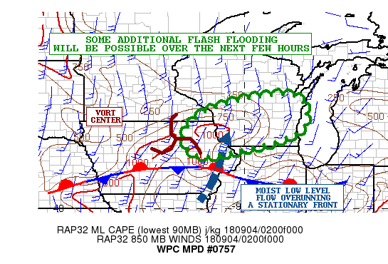
Summary...Clusters of showers and thunderstorms will continue over
the next few hours. Given the wet antecedent conditions and heavy
rainfall rates, the threat of flash flooding will be elevated.

Discussion...Radar imagery shows multiple clusters of showers and
thunderstorms lifting northeast across northeast IA and into
southwest to central portions of WI. The activity over the last
hour has tended to increase in intensity just a bit as the GOES-16
IR satellite imagery has been showing some cooling of the
convective tops. There is some subtle evidence in WV satellite
imagery of a weak vort/shortwave exiting northeast IA and this
coupled with a broad southwest warm air advection pattern
overrunning the front appears to be helping to support the ongoing
activity.

The low level flow overrunning the boundary is generally on the
order of 20 to 30 kts as per the latest VAD wind profiler data and
there is a nose of modest instability north of the front on the
order of 500 to 1000 j/kg. This coupled with the aforementioned
vort energy aloft should favor some additional convection moving
across southwest to central WI in particular over the next 3 to 4
hours.

The PWATS across the region are on the order of 2.0 to 2.2 inches
which will be conducive to very intense rainfall rates. The latest
HRRR supports as much as an additional 2 to 3 inches of rain going
through 06Z, with potentially some additional rainfall thereafter.
Given the wet antecedent conditions, and additional rainfall,
there will continue to be concerns for flash flooding.

Orrison

ATTN...WFO...ARX...DMX...DVN...GRB...MKX...

ATTN...RFC...NCRFC...

LAT...LON   44488940 44448780 43348760 42788852 42448989
            42129134 42189198 42589235 43099238 43539201
            43929145
Last Updated: 1105 PM EDT Mon Sep 03 2018
|


