| WPC Met Watch |
|
|
Mesoscale Precipitation Discussion: #0757 (2023) |
|
(Issued at 114 PM EDT Tue Jul 18 2023
) |
|
| MPD Selection |
|
|
|
|
|

Mesoscale Precipitation Discussion 0757
NWS Weather Prediction Center College Park MD
114 PM EDT Tue Jul 18 2023

Areas affected...Missouri, southern Illinois, far western Kentucky

Concerning...Heavy rainfall...Flash flooding possible

Valid 181713Z - 182300Z

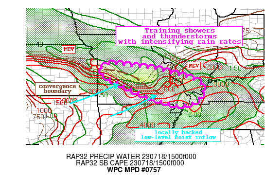
Summary...Showers and thunderstorms will intensify along a
low-level convergent axis through the afternoon before an MCS
sweeps through to the southeast. This convection will likely train
with 1-2"+/hr rain rates, producing locally more than 3 inches of
rain. Flash flooding is possible.

Discussion...The regional radar mosaic this aftn shows a pair of
MCSs with accompanying MCVs moving southeast across Missouri. The
lead MCS has left a low-level convergent boundary in its wake,
into which subtly backing flow downstream of the second MCV is
impinging more orthogonally to drive ascent. This is resulting in
an expanding line of convection with radar-estimated rain rates of
1.5-2"/hr according to KLSX. The environment across the area is
characterized by PWs of 1.7-1.9 inches within the pre-convective
environment, and MUCAPE of 2000 J/kg just south of this line. This
locally backed low-level flow will continue to transport these
thermodynamics northward into the boundary and along the
impressive SBCAPE gradient, and convection is likely to persist
until the second MCV sweeps through later this aftn.

The high-res guidance is unfortunately very different in its
evolution of the simulated reflectivity fields today. As the 850mb
flow backs more to the south and increases to 15-20 kts, it should
drive the best CAPE northward while also isentropically ascending
the remnant convergent boundary. With impressive PWs remaining in
place, these ingredients suggest convection will redevelop across
this axis and then train to the southeast on boundary parallel
0-6km mean winds of 20-30 kts. Additionally, effective bulk shear
increasing to 50-60 kts will allow for increasing storm
organization, driving rain rates to 2"/hr or more at times. While
the heaviest rain is likely along this axis before the MCS sweeps
through later today, locations that receive training along the
boundary and the subsequent MCS, could receive more than 3 inches
of rain before precip winds down this evening.
Confidence in the exact placement of the heaviest axis is modest,
but HREF EAS probabilities for more than 1 inch peak above 25%
along and just northeast of the surface boundary.

Recent rainfall across this part of Missouri and southern Illinois
has been more than 300% of normal according to the 7-day AHPS
rainfall departures. This has lowered FFG to 1.5"/1hr and
2.5"/3hrs which may be exceeded in the most pronounced training.
This could result in instances of flash flooding before the MCS
sweeps through and brings an end to precipitation from NW to SE by
this evening.


Weiss

ATTN...WFO...EAX...LSX...MEG...PAH...SGF...

ATTN...RFC...LMRFC...MBRFC...NCRFC...OHRFC...NWC...

LAT...LON   38859389 38579133 38289020 37948900 37668851
            37288842 36818868 36588907 36539013 37059173
            37639309 38099392 38359441 38679433
Last Updated: 114 PM EDT Tue Jul 18 2023
|


