| WPC Met Watch |
|
|
Mesoscale Precipitation Discussion: #0760 (2020) |
|
(Issued at 1137 PM EDT Tue Sep 15 2020
) |
|
| MPD Selection |
|
|
|
|
|

Mesoscale Precipitation Discussion 0760
NWS Weather Prediction Center College Park MD
1137 PM EDT Tue Sep 15 2020

Areas affected...Gulf Coast from Mobile Bay, AL to Apalachee Bay,
FL

Concerning...Heavy rainfall...Flash flooding likely

Valid 160337Z - 160930Z

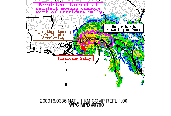
Summary...Significant and life threatening flash flooding
developing along the immediate Gulf Coast from Gulf Shores, AL to
Destin, FL associated with Hurricane Sally. Rain bands and the CDO
lifting slowly onshore will drive intensifying rain rates to
2+"/hr within the CDO, and up to 3"/hr in convective spiral bands.
Additional rainfall in the next 6 hours of 2-4" with isolated
amounts above 6" is possible. This will exacerbate ongoing flash
flooding through the early morning.

Discussion...The eye of Hurricane Sally is evident from KMOB radar
lifting slowly northward, centered approximately 65 miles SSE of
Mobile, AL at 03Z. GOES-E IR imagery indicates that cloud tops are
continuing to cool both around the eye of Sally, and within spiral
rain bands east of the center. This is indicative of a
strengthening hurricane with intensifying rain rates. Rainfall
across portions of the Gulf Coast between Gulf Shores, AL and
Destin, FL have been generally 5-10" in the last 24 hours, with
lesser but still significant rainfall further east towards
Apalachicola, FL and north away from the immediate coast. Recent
1-hr rainfall has been observed between 1-1.5" across coastal
Escambia County, FL, coincident with KMOB hourly rain rate
estimates of 1.5-2"/hr, and just north of recent AMSU and SSMI
satellite passes indicating 0.75"/hr, which is likely
underestimating by half due to resolution, suggesting rain rates
in excess of 1.5"/hr.

As Sally continues to lift northward, PWs will climb even beyond
the already extremely anomalous 2.25-2.5" values measured by
recent GPS observations. While CAPE has been limited to the
immediate shoreline so far, intensifying S/SE 850mb low level
winds east of the center should supply more robust instability
transport allowing MUCape to climb towards 2000 J/kg along the
immediate coast, with upwards of 500 J/kg surging north of the
AL/FL line. This will occur in conjunction with persistent upper
divergence within the anticyclonic outflow N/NE of Sally and
intense low-level mass confluence to drive deep layer ascent in
the increasingly favorable thermodynamic environment. Rainfall
rates are likely to increase overnight, and the HREF probabilities
suggest 3"/hr rates are possible as the eye of Sally approaches.

The most persistent rainfall will occur within the CDO and near
the eyewall of Hurricane Sally, which is progged to come onshore
near the AL/FL line early Wednesday. Within this CDO, 1"/hr rates
will likely be nearly continuous, and may reach 3"/hr at times
near the coast where instability is maximized. Parts of Baldwin
County, AL and Escambia County, FL are already experiencing
significant flash flooding, so additional rainfall which may reach
6" or more in the next 6 hours will likely enhance the flash
flooding to widespread and life-threatening. Further east along
the remainder of the FL Panhandle, rainfall has been slightly less
so far. However, training of spiral rain bands with rain rates
which may periodically also approach 3"/hr will increase/enhance
flash flooding. Here, 2-4" with locally higher amounts are likely
which will also enhance ongoing flash flooding. Although heavy
rainfall will begin to expand northward, the most significant
flash flood risk will remain confined near the coast through early
morning as antecedent rainfall, and instability, are much less
north of Mobile Bay, AL.

Weiss

ATTN...WFO...MOB...TAE...

ATTN...RFC...LMRFC...SERFC...NWC...

LAT...LON   30998753 30968758 30968699 30938632 30748580
            30508518 30218477 29918465 29738474 29598500
            29968561 30158599 30288640 30278679 30208719
            30178756 30158783 30148806 30168821 30298823
            30548817 30728804 30918775
Last Updated: 1137 PM EDT Tue Sep 15 2020
|


