| WPC Met Watch |
|
|
Mesoscale Precipitation Discussion: #0761 (2020) |
|
(Issued at 516 AM EDT Wed Sep 16 2020
) |
|
| MPD Selection |
|
|
|
|
|

Mesoscale Precipitation Discussion 0761
NWS Weather Prediction Center College Park MD
516 AM EDT Wed Sep 16 2020

Areas affected...Central Gulf Coast from Mobile Bay, AL to
Apalachee Bay, FL inland to southern AL

Concerning...Heavy rainfall...Flash flooding likely

Valid 160915Z - 161400Z

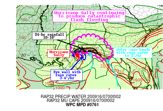
Summary...Hurricane Sally making landfall along the coast of
Baldwin County, AL will lift slowly northward through late
morning. Heavy rainfall will continue to pivot onshore with rain
rates of 2"/hr in the outer bands, and as high as 4"/hr within the
eye wall. This rain is falling upon areas that have seen as much
as 18" of rain already from this event, and catastrophic flash
flooding is occurring. Life-threatening flash flooding will spread
slowly northward along and east of the track of Sally.

Discussion...Reflectivity out of KMOB WSR-88D indicates that the
eye of Hurricane Sally is very close to making landfall along the
coast of Baldwin County, AL. While this will finally begin a
weakening trend of the hurricane, torrential rainfall will
continue along and east of the center through the morning.
Rainfall rates recently have been estimated by KMOB to be near
4"/hr within the eye wall, and Hurlburt Field, FL measured 2.68"
within the last hour. In addition to the eye wall, multiple spiral
rain bands noted on the regional radar composite and GOES-E IR
imagery were rotating onshore across the FL Panhandle with
additional heavy rainfall. This rain was occurring on top of soils
that have already received locally as much as 18" of rainfall from
Sally, and widespread flash flooding is ongoing, some of which is
catastrophic. Additional rainfall will only prolong and expand
this life threatening situation.

As Hurricane Sally pivots onshore, it will gradually pick up speed
to the north/northeast. However, continuous rainfall of 1-2"/hr
with local rates nearing 4"/hr will persist within the eye wall as
it lifts north. The recent 06Z WoFS indicates a high probability
for more than 5" of additional rainfall for Baldwin, AL and
Escambia, FL counties, with high probabilities for 3" spreading as
far north as Escambia, AL county, and this is echoed by the recent
HREF probabilities. These locations will have the strongest
forcing due to low level moisture confluence and upper level
diffluence, occurring within an environment characterized by PWs
which were observed on the special 06Z soundings to be 2.2-2.4",
and warm cloud depths to 16,000 ft. Although the CAMs vary in
their speed and northward progression of the heaviest rainfall,
the recent runs of the HRRR, Conest, and ARW2 suggest rainfall in
the next 6 hours could locally reach 8" within the eye wall, and
2-5" elsewhere.

Further east across the Panhandle of Florida as far east as
Apalachee Bay, pivoting rain bands will continue to lift onshore
through the morning. In this region, 850mb inflow is not as
strong, but is still exceeding the mean 850-300mb wind to drive
local ascent, and is rotating from the central Gulf of Mexico
prolonging the parcel residence time across warm waters for
saturation. This is evident by increasing 700-500mb and 500-300mb
LPW within this spiral bands, which then lift onshore around
Sally. While these bands won't feature the continuous heavy
rainfall as within the eye wall due to their more convective
nature, training of rain rates which could exceed 2"/hr will
produce an additional 2-4" of rainfall, with locally higher
amounts. This will also prolong and enhance flash flooding, with a
more robust northward push of the heavy rainfall developing late
morning as instability increases away from the coast.


Weiss

ATTN...WFO...BMX...MOB...TAE...

ATTN...RFC...LMRFC...SERFC...NWC...

LAT...LON   31828617 31668579 31458537 31218509 30938486
            30478450 30178444 29968449 29848463 29738484
            29658504 29728533 29998569 30248616 30388656
            30388705 30328735 30278766 30258787 30318811
            30468821 30688820 31138800 31498769 31678736
            31798694
Last Updated: 516 AM EDT Wed Sep 16 2020
|


