| WPC Met Watch |
|
|
Mesoscale Precipitation Discussion: #0761 (2023) |
|
(Issued at 115 AM EDT Wed Jul 19 2023
) |
|
| MPD Selection |
|
|
|
|
|

Mesoscale Precipitation Discussion 0761
NWS Weather Prediction Center College Park MD
115 AM EDT Wed Jul 19 2023

Areas affected...much of MO...southern IL...western KY...portions
of West and Middle TN

Concerning...Heavy rainfall...Flash flooding likely

Valid 190600Z - 191200Z

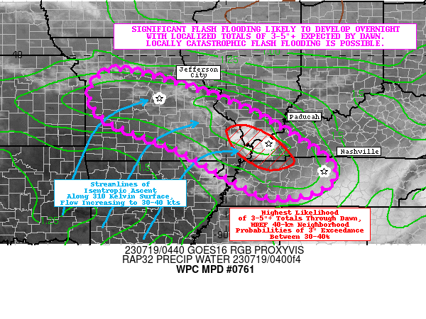
Summary...Areas of significant flash flooding are likely to
develop overnight with localized totals of 3-5"+ expected by dawn.
Locally catastrophic flash flooding is possible, particularly in
the vicinity of Paducah (including surrounding portions of
MO/IL/TN).

Discussion...Convection has begun to initiate in the vicinity of
the MO/IL/KY Tristate area, very near where the consensus of the
00z HREF guidance indicated (and shortly after a line of cumulus
became evident via GOES-East infrared imagery, likely near an old
outflow boundary from earlier convection). While a surface front
has been analyzed by WPC about 50 miles north of where initiation
has occurred, the convection is likely a bit elevated, as it is
coming about from strong boundary layer moisture convergence via
isentropic ascent along (and near) the 310 Kelvin surface (with
flow increasing to 30-40 kts). This serves as a much better proxy
of the low-level jet (as compared to a isobaric surface of 850
mb), and convection is likely to proliferate upstream into central
MO along this convergence axis. The mesoscale environment across
this broad convergence axis is characterized by an ML CAPE
gradient of 500-2000 J/kg (increasing to 1000-2500 J/kg),
precipitable water values that are rapidly increasing to 1.8-2.3
inches (near the max moving average, per SGF and BNA sounding
climatology), and strong deep layer shear of 40-50 kts.

There is increasing concerns for significant to potentially
catastrophic flash flooding developing overnight and into the
early morning in association with training convection, as the
strengthening low-level jet looks to supply ample moisture
transport to support long-lived deep convection in an increasingly
unstable and exceedingly moist tropospheric column. As expected,
the 00z HREF depicts a concerning evolution, with the
probability-matched mean QPF indicating 3-5"+ localized totals in
the MO/IL/KY Tristate area (and edging into portions of northern
West and Middle TN) for the 6-hr period ending at 12z. The
associated 40-km neighborhood exceedance probabilities for 3" and
5" thresholds indicate a maxima of 30-40% and 5-10%, respectively.
While probabilities are a bit lower for the 3" threshold to the
west across much of central MO (generally 20-30%), very
interestingly the 5" probabilities are actually higher just south
of Jefferson City (with a maxima of 15-25%). This is due to a
bi-modal distribution amongst the HREF members, with the most
intense members (the ARW2 and the NAM-nest) having the best QPF
and training axis farther upstream. Given the current
observational trends, this scenario seems less likely.. and the
probability-matched mean QPF accurately depicts this discrepancy,
only indicating 2-3" localized totals in the vicinity of the
Jefferson City. Even still, this amount of rainfall will be enough
to cause at least scattered instances of flash flooding across
central MO, as Flash Flood Guidance (FFGs) are indicated to be as
low as 1.5-2.0" (over 3-hr) across the region. Downstream into the
Tri-State area, FFGs are generally 2.0-3.0" (over 3-hr).

Despite the fair amount of spread in the 00z CAM guidance (and the
likely underdone QPF amounts from the non-ARW2/NAM-nest members
for the primary area of concern), scattered to numerous flash
floods are considered likely along the majority of the expected
training axis (from central MO south-southeast into north-central
portions of West and Middle TN). The highest confidence for flash
flooding exists across the aforementioned Tristate area where
repeating cells with an increasingly linear orientation are
already developing. With MRMS already indicating 15-min totals
approaching 1". Hourly accumulations will quickly ramp up to 2-3"+
where storms train most efficiently, and this could very well
result in localized totals of 5" or greater before dawn. Therefore
isolated to scattered instances of significant (i.e. life
threatening) flash flooding are considered likely, and there is
the potential for locally catastrophic flash flooding should these
short-term totals of 5"+ be realized. While convection should be
coming to an end across central MO by 12z, the HREF indicates that
backbuilding of storms may continue in the Tristate area (and into
downstream areas of TN) where subsequent MPDs will likely be
needed.

Churchill

ATTN...WFO...EAX...LMK...LSX...LZK...MEG...OHX...PAH...SGF...

ATTN...RFC...LMRFC...MBRFC...NCRFC...OHRFC...NWC...

LAT...LON   39479370 38959137 38288960 37418796 36248645
            35538707 35388866 35988989 36909155 37859388
            38759444
Last Updated: 116 AM EDT Wed Jul 19 2023
|


