| WPC Met Watch |
|
|
Mesoscale Precipitation Discussion: #0761 (2024) |
|
(Issued at 527 PM EDT Tue Jul 30 2024
) |
|
| MPD Selection |
|
|
|
|
|

Mesoscale Precipitation Discussion 761
NWS Weather Prediction Center College Park MD
527 PM EDT Tue Jul 30 2024

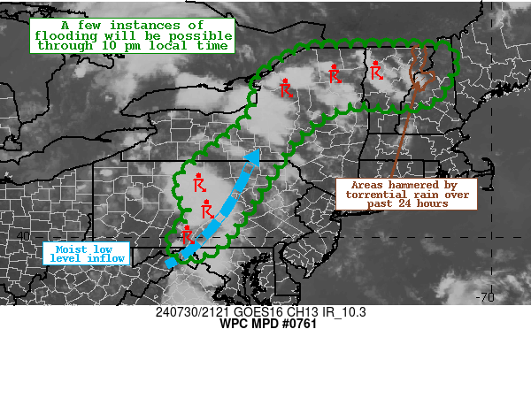
Areas affected...Central PA...Central NY...Northern VT...Northern
NH

Concerning...Heavy rainfall...Flash flooding possible

Valid 302127Z - 310200Z

Summary...Showers and storms are expected to persist through the
evening hours.  Multiple rounds of heavy rainfall are expected for
portions of the outlook area, and some instances of flash flooding
will be possible where high rainfall rates persist over any given
area through 10 pm local time.

Discussion...Regional Doppler radars are indicating an increase in
multi-cellular convection across northern New York, and a separate
area of training convection across portions of south-central PA.
The overall environment is becoming conducive for heavy rainfall,
with PWs increasing to near 1.7 to 2.0 inches per recent SPC
mesoanalysis, along with mixed layer CAPE on the order of 1500 to
2000 J/kg.  A moist 850 mb flow of 20-30 mph from the southwest is
advecting copious moisture into the region, and the potential
exists for some back-building convection that could result in some
1-2 inch per hour rainfall rates.

The latest CAM guidance has some scattered enhanced QPF maxima
north of the Interstate 90 corridor in Upstate New York, and also
across portions of central PA, with the NAM conest, FV3, and to a
lesser extent the HRRR picking up on this potential.  Portions of
northern Vermont and New Hampshire that were hammered with
torrential rainfall last night will be more susceptible to
flooding issues if slow moving storms develop across that area.

Hamrick

ATTN...WFO...ALY...BGM...BTV...BUF...CTP...GYX...LWX...

ATTN...RFC...MARFC...NERFC...OHRFC...NWC...

LAT...LON   45047296 45037201 44877100 44177118 43617162
            43467251 43537358 43187452 42577524 41997564
            41237615 40037698 39537769 39547839 40017845
            40597794 41197827 41667817 42407722 43257631
            44207613 44937495 45037401
Download in GIS format: Shapefile
| KML
Last Updated: 527 PM EDT Tue Jul 30 2024
|


