| WPC Met Watch |
|
|
Mesoscale Precipitation Discussion: #0762 (2023) |
|
(Issued at 804 AM EDT Wed Jul 19 2023
) |
|
| MPD Selection |
|
|
|
|
|

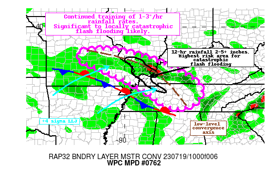
Mesoscale Precipitation Discussion 0762
NWS Weather Prediction Center College Park MD
804 AM EDT Wed Jul 19 2023

Areas affected...eastern MO, southern IL, western KY, western TN

Concerning...Heavy rainfall...Flash flooding likely

Valid 191203Z - 191800Z

Summary...Thunderstorms developing along a NW to SE oriented
convergence axis will persist through the morning. These
thunderstorms will have rain rates of 1-3"/hr at times, which
through training could produce locally more than 5" of rain. This
will occur on top of saturated soils. Flash flooding is likely,
some of which could be significant and life-threatening.

Discussion...The regional radar mosaic this morning shows a
continuation of an impressive NW to SE oriented MCS developing
along a low-level convergent axis from eastern Missouri through
central Tennessee. Convection has been ongoing all night along
this boundary, and is likely to continue for several more hours as
the 850mb LLJ of 30-40 kts noted on regional VWPs, more than +4
standard deviations according to the SREF, continues to lift into
the area. A stationary front analyzed by WPC just south of the
convection is serving as another lifting mechanism as the LLJ
rises impressively and isentropically atop this boundary and then
collides into the convergence axis to the northeast. MUCAPE
according to the SPC RAP analysis remains 2000-3000 J/kg, with PWs
measured by GPS as high as 1.9-2.0 inches, around the 90th
percentile for the date. These extreme thermodynamics will
continue to surge into the area on this LLJ, maintaining an
environment favorable for 1-3"/hr rainfall rates.

The high-res guidance still features some differences in where the
heaviest rain axis will setup this morning, but recent runs of the
HRRR, ARW, and CONEST are all initializing well enough to be
helpful. It is likely that convection will continue to develop and
train SE on 10-15 kts Corfidi vectors, with backbuilding occurring
into the greater instability to the west as the LLJ begins to
gradually veer. Impressive thickness diffluence positioned over
western KY and into TN should also support continued intensity of
these thunderstorms. What is concerning is that despite the
thickness lines suggesting this complex will try to dive southeast
with time, that will be offset both by weaker instability east and
the veering of the LLJ, indicating the overall footprint of the
heaviest rainfall will likely be narrow along the greatest
moisture transport vector convergence, and across similar areas
already impacted overnight. 12-hr rainfall from MRMS and mesonet
observations has already been 2-5" with locally higher amounts,
and the HREF exceedance probabilities for 3" and 5" reach 40% and
25%, respectively, atop these same areas.

The heavy rain overnight is already leading all-time high USGS
streamflows and flash flooding. With soils already saturated, any
additional rain will lead to rapid runoff and flash flooding.
Should the axis of heavy rain focus atop the same areas, this
could result in locally catastrophic and life-threatening flash
flooding, with maximum rainfall possibly reaching 8-10" for the
entire event. Even in areas that haven't received as much rainfall
overnight, the training of 1-3"/hr rain rates could produce 1-3+"
of rain leading to other instances of flash flooding through the
late morning.

Weiss

ATTN...WFO...HUN...LMK...LSX...MEG...OHX...PAH...SGF...

ATTN...RFC...LMRFC...MBRFC...NCRFC...OHRFC...NWC...

LAT...LON   38619199 38599061 38248906 37708756 36838592
            36278548 35758570 35438603 35228690 35458772
            35728810 36268884 36718968 37289079 37609155
            37879227 38059263 38419269
Last Updated: 804 AM EDT Wed Jul 19 2023
|


