| WPC Met Watch |
|
|
Mesoscale Precipitation Discussion: #0765 (2020) |
|
(Issued at 412 AM EDT Thu Sep 17 2020
) |
|
| MPD Selection |
|
|
|
|
|

Mesoscale Precipitation Discussion 0765
NWS Weather Prediction Center College Park MD
412 AM EDT Thu Sep 17 2020

Areas affected...central/northern GA into western SCh

Concerning...Heavy rainfall...Flash flooding likely

Valid 170812Z - 171400Z

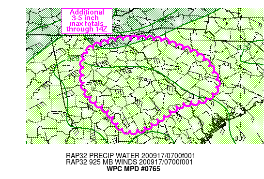
Summary...Flash flooding, some of which could be significant, will
continue across portions of central GA into western SC over the
next few hours. Rainfall rates of 1-2 in/hr, with localized rates
between 2-3 in/hr are expected to produce an additional 3-5 inches
through 14Z.

Discussion...Regional radar imagery showed the highest rainfall
rates associated with T.D. Sally over central GA, near Macon, with
observations ending 08Z between 2 and 2.5 in/hr (2.42 in/hr at
MCN). This region is where an inflow feeder band, extending from
Apalachee Bay into south-central GA, intersected an elevated
frontal boundary, maximizing low level moisture flux convergence
over central GA. Infrared satellite imagery continues to show a
very favorable outflow pattern within the northern semi-circle of
the storm system. While surface observations have shown the center
of Sally has made very slow progress over southeastern AL since
00Z, water vapor imagery showed the mid-upper level reflection of
the tropical cyclone has been decoupling from the surface cyclone
with a steady movement noted off toward the northeast.

Over the next 3-6 hours, the strong region of low level moisture
flux convergence in place over central GA will continue to slowly
but steadily progress off toward the east-northeast. Expect
rainfall rates of 1-2 in/hr, locally higher, to translate from
central GA into western SC. In addition, steady rainfall rates of
0.5 to 1 in/hr within the stratiform region of heavy rain over
northern GA will slowly expand eastward into SC through the
morning with rainfall totals of 1-3 inches expected over the next
6 hours. Additional rainfall totals of 3-5 inches are likely from
central to eastern GA along with continued areas of flash
flooding.

Otto

ATTN...WFO...CAE...CHS...FFC...GSP...

ATTN...RFC...LMRFC...SERFC...NWC...

LAT...LON   34858346 34838247 34618180 34318117 33658071
            33258085 33088115 32938180 32548239 32248287
            32178316 32198346 32438366 32788392 33088434
            33368457 33758463 34478453 34768391
Last Updated: 412 AM EDT Thu Sep 17 2020
|


