| WPC Met Watch |
|
|
Mesoscale Precipitation Discussion: #0775 (2024) |
|
(Issued at 321 PM EDT Thu Aug 01 2024
) |
|
| MPD Selection |
|
|
|
|
|

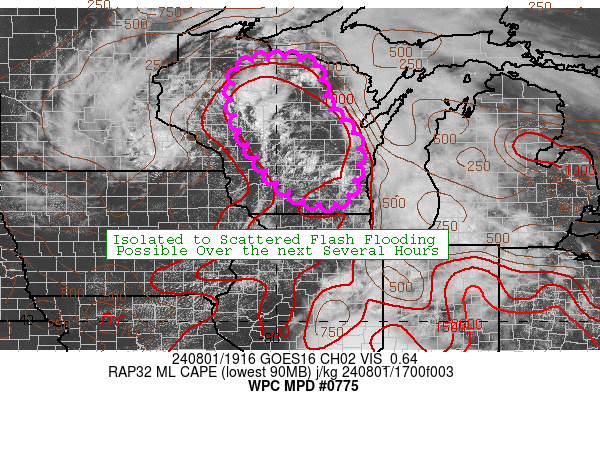
Mesoscale Precipitation Discussion 0775
NWS Weather Prediction Center College Park MD
321 PM EDT Thu Aug 01 2024

Areas affected...Central Wisconsin

Concerning...Heavy rainfall...Flash flooding possible

Valid 011920Z - 020120Z

Summary...Expanding slow moving convection may result in isolated
to scattered flash flooding over the next several hours across
portions of Wisconsin.

Discussion...Convection is expected to continue to increase in
coverage over central WI over the next few hours as a well defined
mid level low moves into the area. Already seeing slow moving
convection near a stationary front, and the approaching mid level
low should only increase forcing over this region. The stationary
front over the area will act as a persistent low level forcing
mechanism, which combined with relatively weak deep layer mean
flow, supports slow moving and repeat convection. PWs across this
axis are around 1.7" and MLCAPE around 1500 j/kg...both supportive
of heavy rainfall rates. IR imagery indicates the ongoing
convection is not all that deep...with the more shallow nature of
convection likely indicative of some warm rain processes
increasing rainfall efficiency. As the mid level low approaches
convection will probably grow more vertically with colder cloud
tops...which may decrease rainfall efficiency a tad, although
still would expect heavy rainfall rates. The favorable
thermodynamic environment for heavy rates combined with the slow
storm motions suggests at least an isolated to scattered flash
flood risk will exist over the next few hours.

The 12z HREF neighborhood probabilities of 3" are 30-60%, and
localized 3"+ totals are supported by recent HRRR runs as well.
The one limiting factor is the general lack of deep layer shear to
organize/maintain convection. Without this ingredient convection
will probably pulse up and down in intensity and likely limit the
upper bound of rainfall totals. This is also indicated by the
significant drop in 5" exceedance probabilities from the HREF
compared to 3". Overall expect convection to be capable of
localized ~2"/hr rainfall, with totals over the next 6 hours
locally getting into the 2-4" range. This is expected to result in
at least a few instances of flash flooding.

Chenard

ATTN...WFO...ARX...DLH...GRB...MKX...MPX...

ATTN...RFC...NCRFC...NWC...

LAT...LON   46129002 46128961 46028925 45878904 45368893
            44918877 44378823 43838811 43258819 42808848
            42778922 43239000 43829045 44259073 44939102
            45499104 45839091 46069059
Download in GIS format: Shapefile
| KML
Last Updated: 321 PM EDT Thu Aug 01 2024
|


