| WPC Met Watch |
|
|
Mesoscale Precipitation Discussion: #0780 (2023) |
|
(Issued at 1158 AM EDT Fri Jul 21 2023
) |
|
| MPD Selection |
|
|
|
|
|

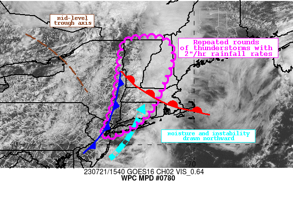
Mesoscale Precipitation Discussion 0780
NWS Weather Prediction Center College Park MD
1158 AM EDT Fri Jul 21 2023

Areas affected...New York through Western New England

Concerning...Heavy rainfall...Flash flooding possible

Valid 211600Z - 212200Z

Summary...Thunderstorms will expand across New England and Upstate
New York this aftn to become widespread. Rain rates of 2"/hr are
likely within this convection, leading to rainfall amounts of 2-3"
with locally higher amounts. Flash flooding is possible.

Discussion...The GOES-E visible imagery this afternoon shows rapid
clearing behind this morning's convection expanding across Upstate
NY and into far western New England. Within this clearing,
agitated Cu are rapidly blossoming, resulting in scattered showers
and isolated thunderstorms. Forcing for ascent is becoming
increasingly impressive across the Northeast as coupled jet
streaks, height falls downstream of a potent shortwave, and the
ascending moist conveyor into a warm front overlap. This will
continue to drive robust deep layer ascent into favorable
thermodynamics characterized by PWs of 1.3-1.5 inches, above the
75th percentile according to the SPC sounding climatology, and
SBCAPE rapidly climbing within clearing to 1500 J/kg. Convection
has been generally disorganized so far, but some of the deeper
cells have produced radar-estimated rain rates above 1"/hr already
this morning.

As the aftn progresses, still robust synoptic lift will interact
with even more intense thermodynamics as 850-500mb flow advects
higher PWs northward noted in the 850-700 and 700-500mb LPW
products, coincident with an increase in SBCAPE to over 2000 J/kg.
This should result in an expansion of convective coverage ahead of
the approaching cold front, with an uptick in intensity also
likely. This is reflected by simulated reflectivity in most of the
available high-res guidance, and HREF neighborhood rain-rate
probabilities rising for both 1"/hr and 2"/hr. Additionally, the
HRRR sub-hourly fields indicate that 15-min rainfall could exceed
0.75" in isolated locations, further reflecting the potential
intensity of the rainfall today. Limiting the flash flood risk
somewhat will be mean 0-6km winds that will remain at 20-30 kts,
but flow aligned to the approaching front combined with effective
bulk shear of 30-40 kts will result in organization to multi-cell
clusters with at least short-term training potential. Where these
clusters exhibit the most impressive rates/training, rainfall
could reach 2-3", with locally higher amounts possible as
reflected by HREF probabilities.

More concerning for the flash flood risk today is simply how wet
this area has been. 14-day rainfall from AHPS has been widespread
300-400% of normal, leading to nearly uniform exceedance of the
90th percentile of USGS streamflow. The vulnerability of the soils
is also reflected by 1-hr FFG as low as 0.75-1". Any of these
intense rates falling atop the sensitive soils could result in
instances of flash flooding today, but the greatest threat appears
to be from the Tri-State area through western New England where
multiple rounds of convection are likely today.


Weiss/Asherman

ATTN...WFO...ALY...BOX...BTV...GYX...OKX...PHI...

ATTN...RFC...MARFC...NERFC...NWC...

LAT...LON   45117186 44857121 44187106 43217138 41927197
            41327241 40917298 40737329 40517374 40427403
            40407438 40907414 42187372 43257360 43797353
            44927331 45057277
Last Updated: 1158 AM EDT Fri Jul 21 2023
|


