| WPC Met Watch |
|
|
Mesoscale Precipitation Discussion: #0783 (2023) |
|
(Issued at 541 PM EDT Fri Jul 21 2023
) |
|
| MPD Selection |
|
|
|
|
|

Mesoscale Precipitation Discussion 0783
NWS Weather Prediction Center College Park MD
541 PM EDT Fri Jul 21 2023

Areas affected...New England...Northeast NY...

Concerning...Heavy rainfall...Flash flooding likely

Valid 212145Z - 220330Z

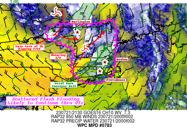
SUMMARY...Multiple Bands of slow moving, strong thunderstorms with
up to 2"/hr rates.  Continue to pose likely scattered incidents of
flash flooding through early overnight period.

DISCUSSION...GOES-E WV suite depicts a highly dynamic mid to upper
level pattern over SE Canada into New England.  The main core of
the upper low is pivoting along the far eastern extent of Ontario
along the Quebec boarder with strong secondary trof digging
through the St. Lawrence Valley toward N VT by the end of the
forecast period.  Moisture is a bit reduced relative to further
south-east across New England, but strong 850-700mb convergence
has increased overall values up to 1.5" due to slightly drier
mid-level.  However, this does steepen lapse rates to strengthen
instability and updraft vigor and with moist low levels in strong
convergence, thunderstorms will be capable of intense rates up to
1.75"/hr.  As such spots of 1.5-2.5" are possible mainly across
far NE NY into VT after 23-01z, before instability wanes with loss
of daytime heating.

Further southeast within the broader southwesterly flow of larger
scale cyclone, very strong thunderstorms with impressive anvils
and broader than normal updraft/downdraft cores for New England
continue to progress slowly across S NH, central MA with a few
trailing cells into E Long Island.  A subtle shortwave is slipping
northeast through S VT, shearing along the way aiding vertical
ascent, while also strengthening confluent southwest to
south-southwest low level flow.  The effective warm conveyor has
much deeper, rich moisture with 1.5 to 1.7" total Pwats and
slightly warmer lower profiles for similar stronger instability
signals to maintain these stronger cores.   Rain rates of 1.5-2"
still remain, but as the wave shears and lifts north, the winds
should abate ever so slightly.  This has a positive affect for
favorable upwind/flanking line redevelopment as well as slows
forward propagation; both increasing rainfall duration.   As such,
scattered to numerous spots of 2-3" are possible across SE NH, MA
into CT, RI), with some suggestion of even spots to near 4" by
03z.  All considered, both areas are likely to continuing seeing
incidents of flash flooding, while a spot or two of considerable
flash flooding are possible in S and SE New England, especially if
occurring in/near urban centers.

Gallina

ATTN...WFO...ALY...BOX...BTV...GYX...OKX...

ATTN...RFC...NERFC...NWC...

LAT...LON   45417058 44237043 42617056 41867057 41207085
            40957169 40947246 41477339 42617347 43177333
            43637378 44067491 44417542 44837540 45137481
            45107245 45167165
Last Updated: 541 PM EDT Fri Jul 21 2023
|


