| WPC Met Watch |
|
|
Mesoscale Precipitation Discussion: #0811 (2023) |
|
(Issued at 121 PM EDT Sat Jul 29 2023
) |
|
| MPD Selection |
|
|
|
|
|

Mesoscale Precipitation Discussion 0811
NWS Weather Prediction Center College Park MD
121 PM EDT Sat Jul 29 2023

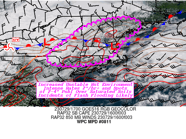
Areas affected...Southeast Upstate NY...Much of New England...

Concerning...Heavy rainfall...Flash flooding likely

Valid 291730Z - 292300Z

SUMMARY...Risk of flash flooding expanding into New England ahead
of the approaching shortwave.  Heavy rainfall of 2-4" crossing
fairly saturated soils, likely to induce scattered to numerous
localized incidents of flash flooding through Saturday evening.

DISCUSSION...Downstream of MPD 810 currently in affect across much
of Upstate NY, reduced cloud cover across SE NY into New England
in proximity to the west to east stationary front generally
near/just north of the MA and VT/NH state boarder.  Pooled deep
layer moisture of 1.5-1.75" total PWATs and surface Tds in the
upper 60s to low to mid 70s combined with the increased insolation
has resulted in CAPEs increasing into the 1500+ J/kg range.

Weaker capped environment, nearer the surface boundary with some
enhanced mountain circulation convergence at the peaks of the
Catskills, Green and White Mtns is starting to result in scattered
Tcu ahead of the main shortwave still back across W NY.  As the
wave approaches, better divergence aloft combined with backing low
level flow and increasing deep layer moisture flux convergence
will allow for convective expansion across New England.  Having
greater heating, vigor of the updrafts will support further
isallobaric acceleration of localized flow increasing rainfall
production/efficiency for thunderstorms especially after 21z; with
HRRR 15 minute rainfall totals suggest 1.25-1.5" values,
indicative of this efficiency.  Deep layer steering suggests
25-35kts of forward speed to limit duration of the expanding
convective line, but short-term training in line segments are
probable to increase duration for spots of 2-3" over a 1-2 hours.
Additionally, there will be cells that develop well east of the
expanding linear convective band, these cells are likely be very
slow moving given approach of stronger height-falls hinting at
upwind propagation vectors.  These more isolated spots may see
3-4" totals when all is over having the best chance of inducing
flash flooding.

However, the region, particularly east of the Hudson River Valley
into Massachusetts and the upper Connecticut River Valley has seen
recent heavy rainfall with continued saturated soil conditions in
places given AHPS 7-14 day anomalies remain well above normal
(200-400%).  As such, flash flooding is considered likely across
the area of concern with scattered to numerous incidents of flash
flooding probable through the evening hours.

Gallina

ATTN...WFO...ALY...BGM...BOX...BTV...GYX...OKX...

ATTN...RFC...MARFC...NERFC...NWC...

LAT...LON   44796980 44256900 43177036 42277096 41587218
            41377414 41527566 42047584 42877482 44027334
            44647164
Last Updated: 121 PM EDT Sat Jul 29 2023
|


