| WPC Met Watch |
|
|
Mesoscale Precipitation Discussion: #0830 (2018) |
|
(Issued at 1111 AM EDT Thu Sep 13 2018
) |
|
| MPD Selection |
|
|
|
|
|

Mesoscale Precipitation Discussion 0830
NWS Weather Prediction Center College Park MD
1111 AM EDT Thu Sep 13 2018

Areas affected...Lower Outer Banks, Crystal Coast, & Cape Fear of
NC

Concerning...Heavy rainfall...Flash flooding possible

Valid 131511Z - 132111Z

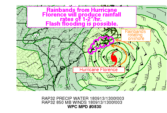
Summary...Outer rainbands from Hurricane Florence will rotate into
eastern North Carolina into this afternoon. Rainfall rates of up
to 2 inches per hour are possible which may produce flash flooding.

Discussion...The initial rain band from Hurricane Florence is
evident on KMHX WSR-88D radar rotating onshore into eastern North
Carolina. The heaviest rainfall is lurking offshore and will
slowly migrate westward as Florence tracks towards the coast, but
rainfall rates of 1-2"/hr have been estimated by KMHX radar in the
stronger convective elements within these first outer rainbands.

PWAT analysis this morning from KMHX upper air sounding and the
blended TPW product suggest values of 2 to 2.4 inches across
extreme eastern NC, with higher values expected to advect inland
through the afternoon. Strong omega/upward vertical motion due to
upper diffluence within the anticyclone atop Hurricane Florence,
combined with increasing 850mb winds and moisture transport will
create very heavy rainfall in an environment characterized by RAP
analyzed MLCape of 500-1000 J/kg and freezing levels of 15-16 kft
on the morning upper air sounding from KMHX. Maximum column lapse
rates are only near 6 C/km, near moist-adiabatic values, which are
supportive of updrafts capable of efficient warm
collision/coalescence processes.

As Florence tracks westward, rainbands will likely expand into an
environment favorable for strengthening due to 0-6km bulk shear of
40 kts and increasing MLCape. The flash flood potential will
remain very close to the coast along Cape Fear however, at least
initially, due to drier air and low-level CIN which needs to be
overcome.  Soil saturation is not initially a problem as rainfall
over the past couple weeks has been ~10% of average.

Despite rapid cell motion on increasing N/NE winds, training of
echoes is expected particularly within Florence's Central Dense
Overcast where rainfall efficiency normally increases within a
hurricane.  This will create the potential for 2-4" with locally
higher amounts possible near Cape Lookout over the next several
hours. These will have the potential to produce flash flooding.

Weiss

ATTN...WFO...ILM...MHX...

ATTN...RFC...SERFC...

LAT...LON   35137689 35097664 35117624 35117591 35027586
            34887610 34767633 34627646 34577664 34607684
            34577709 34497730 34377752 34227769 34067780
            34017778 33817792 33707797 33707805 33797808
            33937805 33957804 34117795 34437777 34677762
            34917736 35017723 35127695
Last Updated: 1111 AM EDT Thu Sep 13 2018
|


