| WPC Met Watch |
|
|
Mesoscale Precipitation Discussion: #0832 (2023) |
|
(Issued at 149 AM EDT Wed Aug 02 2023
) |
|
| MPD Selection |
|
|
|
|
|

Mesoscale Precipitation Discussion 0832
NWS Weather Prediction Center College Park MD
149 AM EDT Wed Aug 02 2023

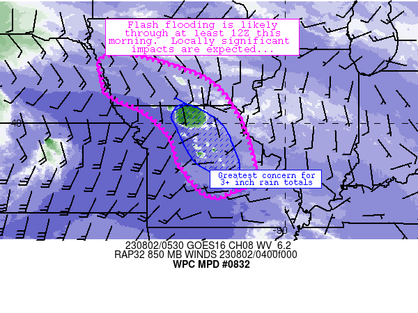
Areas affected...southern Iowa, much of northern through eastern
Missouri

Concerning...Heavy rainfall...Flash flooding likely

Valid 020548Z - 021200Z

Summary...Areas of thunderstorms are expected to train and repeat
across portions of the discussion area through at least 12Z this
morning.  Flash flooding is likely and significant impacts are
expected.

Discussion...Deep convection has begun to materialize across
northern Missouri over the past hour or so.  The storms are
developing in tandem with increasing low-level convergence on the
nose of a strengthening low-level jet across Kansas.  The updrafts
are also embedded in a moderately unstable and very moist airmass
characterized by 2000 J/kg MUCAPE and areas of 2+ inch PW values.
The airmass should support efficient rainfall production with
developing storms.  Meanwhile, the axis of strengthening low-level
convergence was parallel to west-northwesterly flow aloft, which
should allow for areas of training and repeating along that axis
especially if upscale growth of cells into forward-propagating
linear segments stays limited (as suggested by several CAMs).

The unfolding scenario appears to support several hours of heavy
rainfall occurrence (and 1.5-3 inch/hr rain rates) along a general
axis from near TQE in western Iowa to near/south of COU in central
Missouri.  Several areas of 4-7 inch rainfall totals are also
expected through 12Z especially in central and north-central
Missouri.  These totals are expected to eclipse FFG thresholds and
result in areas of potentially significant flash flooding -
especially if heavier rainfall materializes across low-lying or
flash flood prone areas.  Additionally, latest models suggest that
the flash flood risk will persist beyond 12Z in most of the
discussion area.

Cook

ATTN...WFO...DMX...DVN...EAX...FSD...LSX...OAX...SGF...

ATTN...RFC...MBRFC...NCRFC...NWC...

LAT...LON   42279507 41519272 40459172 38989112 38159109
            37749174 37609259 38619351 39589384 40449480
            40979593 41529611 41909621 42209609
Last Updated: 149 AM EDT Wed Aug 02 2023
|


