| WPC Met Watch |
|
|
Mesoscale Precipitation Discussion: #0834 (2018) |
|
(Issued at 544 AM EDT Fri Sep 14 2018
) |
|
| MPD Selection |
|
|
|
|
|

Mesoscale Precipitation Discussion 0834
NWS Weather Prediction Center College Park MD
544 AM EDT Fri Sep 14 2018

Areas affected...eastern NC

Concerning...Heavy rainfall...Flash flooding likely

Valid 140943Z - 141531Z

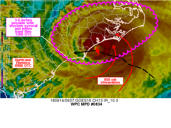
Summary...Heavy rainfall with the eyewall of Florence and an
expected inflow band to the east of Florence's center are expected
to generate significant flooding/flash flooding over eastern NC.
3-6 inches appears likely with these features.

Discussion...Infrared satellite imagery showed the formation of a
curved band signature to the east of Florence's eyewall, setting
up near Cape Lookout. This feature appeared to be forming within
confluent low level flow within the eastern semi-circle of
Florence's circulation, often seen with landfalling tropical
systems. The slow but steady movement of Florence off to the west
should allow this band to slowly translate west from Cape Lookout
to the New River south of Jacksonville over the next few hours.
Rainfall rates within this band could approach 2-3 in/hr and has
been forecast by recent runs of the HRRR with 3-6 inches of rain
impacting Carteret, Craven, Jones and Onslow counties.

Infrared imagery over the past several hours has also shown an
area of locally colder cloud tops associated with the eyewall of
Florence that began south of the Crystal Coast near 03Z, and has
since wrapped cyclonically around the center of Florence and is
now impacting Onslow and Pender counties as the western eyewall is
making landfall as of 0930Z. While reliable ground truth has been
hard to come by within this axis of heavy rain/wind, KMHX dual-pol
estimates were approaching 2 in/hr as of 0930Z within the western
eyewall and could be underdone given a sometimes seen low-bias in
tropical heavy rain bands. The NHC forecast track for Florence
through 15Z continues the eyewall toward the west or
west-southwest over the next 6 hours which will likely impact
coastal sections of the southern NC coast with significant flash
flooding.

Otto

ATTN...WFO...AKQ...ILM...MHX...RAH...

ATTN...RFC...SERFC...

LAT...LON   36137666 35927535 35227503 34527572 33887686
            33757790 33947862 34407910 35057913 35917815
Last Updated: 544 AM EDT Fri Sep 14 2018
|


