| WPC Met Watch |
|
|
Mesoscale Precipitation Discussion: #0836 (2018) |
|
(Issued at 1244 PM EDT Fri Sep 14 2018
) |
|
| MPD Selection |
|
|
|
|
|

Mesoscale Precipitation Discussion 0836...Corrected
NWS Weather Prediction Center College Park MD
1244 PM EDT Fri Sep 14 2018

Corrected for Flash Flood Category

Areas affected...Southeast NC & Northeast SC

Concerning...Heavy rainfall...Flash flooding likely

Valid 141434Z - 142034Z

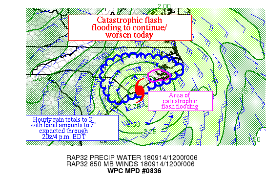
Summary...The main heavy rain focus with Hurricane Florence is
expected to shift to the primary rain band east of its center,
which shows little motion.  Hourly rain totals to 3" and local
amounts to 7" are expected where up to 15" has already fallen.
Catastrophic flash flooding is expected to continue to worsen
today.

Discussion...Hurricane Florence is meandering down the lower NC
coast at this time, with its center currently just west of Kure
Beach.  Hourly rain totals near 3" have been estimated by radar
within its western eyewall, while amounts are coming up within its
main inflow band, estimated at 2" an hour presently.  CoCoRAHS
reports indicate that 14-15" have fallen so far in 1.4 miles north
of Swansboro, whose rain gage may have overflowed -- this is ~60%
of the NC rainfall record for tropical cyclone events (24.06"
during Floyd in 1999), which was recently confirmed by
NCEI/National Centers for Environmental Information.  Gage
observations indicate the 88D radar estimates have been underdone
within this exceedingly moist airmass.

Precipitable water values are ~2.5" within its main inflow band
per the outstanding sounding/weather balloon effort from Morehead
City NC/MHX this morning.  Inflow at 850 hPa is cyclonic at 80 kts
per VAD wind profiles and 88D velocity information, which is near
to slightly above the mean 850-300 hPa wind.  Effective bulk shear
of at least 40 kts along with the deep unidirectional flow around
its center is organizing a significant inflow band which has been
focused primarily into Cartaret County, which is under a Flash
Flood Emergency currently.  The best instability in the ML CAPE
field is near the inflow band, where values are 500-1000 J/kg,
sufficient for rainfall efficiency within an airmass this moist.

Both the mesoscale guidance and conceptual models for tropical
cyclone band behavior during the day indicate that the heavy rain
band over/near Cartaret should remain quasi-stationary today as it
migrates away from the center at nearly the pace of the storm's
forward motion.  Recent ML CAPE trends suggest the instability
gradient in southern NC is moving very little.  Hourly rain totals
to 3" make sense given the instability and moisture available with
the heavy rain focus increasingly shifting from its weakening
eyewall to its primary rain band in southeast NC.  The mesoscale
guidance advertises local amounts of 5-7" during the next several
hours, which looks realistic so long as the band wavers somewhat
during the day.  The heavy rain event for southeast NC is 1/3 to
1/4 over -- plenty of heavy rain remains in the future for this
region.

Roth

ATTN...WFO...AKQ...CAE...ILM...MHX...RAH...

ATTN...RFC...SERFC...

LAT...LON   35987888 35827662 35227548 35077589 34647634
            34577665 34547703 34197762 33857789 33787861
            33507896 33327931 34047995 35338007
Last Updated: 1244 PM EDT Fri Sep 14 2018
|


