| WPC Met Watch |
|
|
Mesoscale Precipitation Discussion: #0837 (2018) |
|
(Issued at 422 PM EDT Fri Sep 14 2018
) |
|
| MPD Selection |
|
|
|
|
|

Mesoscale Precipitation Discussion 0837
NWS Weather Prediction Center College Park MD
422 PM EDT Fri Sep 14 2018

Areas affected...Portions of the Carolinas

Concerning...Heavy rainfall...Flash flooding possible

Valid 142020Z - 150220Z

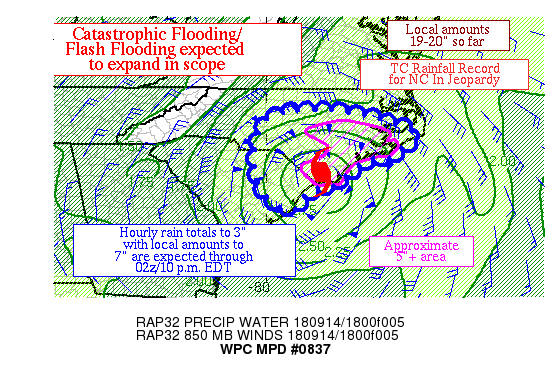
Summary...Florence is producing heavy rain west of its center and
within a stalled inflow band in southeast NC.  Hourly rain totals
to 3" with local amounts to 7" are expected, which could bring
storm total amounts to 24" locally by 02z/10 p.m. EDT.

Discussion...Radar imagery shows Florence meandering westward at 6
mph towards the eastern SC/NC border, with an increasingly diffuse
center.  Heavy rain continues west of the center across southern
Columbus County and continues in a stalled band across Carteret,
Craven, and southern Pimplico Counties.  The Morehead City
Office/MHX reported 19.4" of rain as of 4 p.m./20z.  Precipitable
water values of 2.6" were noted in the 18z sounding from Morehead
City NC/MHX.  Inflow at 850 hPa is 60-70 kts per VAD wind profile
and the recent sounding.  Effective bulk shear of 30-45 kts exists
here, which when combined with the deep unidirectional cyclonic
flow has organized the rain bands in its eastern periphery.  ML
CAPE of 500-1500 J/kg near the persistent band.

The 12z HREF probabilities of 1"+ an hour indicate some westward
drift to the inflow band is expected with time, though the
guidance has definite spread with how quickly it retrogrades.
There have been some hints of this on recent radar imagery and ML
CAPE trends.  Hourly rain totals to 3" remain possible in this
environment, which were occasionally achieved over the past six
hours.  While the mesoscale guidance is not unified in their
solutions for Florence's inflow band, they do indicate local
amounts in the 4-7" are possible over the next several hours.
This would compound existing flooding/flash flooding across
southeast NC and further saturate soils in northeast SC and
central NC with time.  Catastrophic flash flooding remains in the
cards for the NC coast southeast of the Outer Banks.

Roth

ATTN...WFO...CAE...CHS...ILM...MHX...RAH...

ATTN...RFC...SERFC...

LAT...LON   35977840 35687670 35227563 35017602 34607642
            34577708 34197767 33857788 33777852 33527894
            33107926 33397992 34158031 35348021 35827967
Last Updated: 422 PM EDT Fri Sep 14 2018
|


