| WPC Met Watch |
|
|
Mesoscale Precipitation Discussion: #0839 (2018) |
|
(Issued at 1036 PM EDT Fri Sep 14 2018
) |
|
| MPD Selection |
|
|
|
|
|

Mesoscale Precipitation Discussion 0839...Corrected
NWS Weather Prediction Center College Park MD
1036 PM EDT Fri Sep 14 2018

Corrected for change in header to "flash flooding likely" and to
correct a typo in areas affected

Areas affected...northeastern SC into southern NC

Concerning...Heavy rainfall...Flash flooding likely

Valid 150232Z - 150800Z

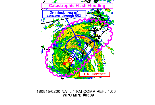
Summary...Intense rain bands with 2-3 in/hr rates will only slowly
translate west across southern NC overnight. Additional rainfall
of 6-9 inches can be expected within the bands through 08Z which
will fall on top of areas already receiving catastrophic
flooding/flash flooding.

Discussion...KMHX radar imagery showed two rain bands to the east
of the center of Tropical Storm Florence as of 02Z. An eastern
band was seen arcing northwestward from Onslow and Carteret
counties into Jones, Lenoir and Wayne counties. KMHX and KRAX dual
pol estimates were 2-3 in/hr within this band. A second, less
intense rain band was noted over southern NC (New Hanover,
Brunswick, Pender, Bladen and Sampson counties) with dual pol
estimates between 1-2 in/hr. Florence continues to slowly move
toward the west-southwest across eastern SC, with the latest NHC
track continuing this movement at roughly 3 mph through the night.

The slow movement of Florence and low level areas of convergence
supporting the intense rain bands should allow for some locations
to receive prolonged periods of rainfall rates between 1-3 in/hr.
The 12Z nmmb had a decent handle on the two rain bands ongoing at
02Z, and forecasts the southern rain band to become dominant over
the next few hours while the eastern/northern band fades. Some of
the latest 00Z hi-res data supports the same idea. The 00/01Z runs
of the HRRR also supports a similar idea with the southern rain
band strengthening over the next couple of hours. Given widespread
coverage of 5-15+ inches since Thursday morning across portions of
southern/eastern NC, major flooding/flash flooding is ongoing in
many areas with roads washed out and water rescues ongoing. An
additional 6+ inches of rain for these locations will only worsen
an already dangerous, life-threatening situation.

Otto

ATTN...WFO...AKQ...CAE...CHS...ILM...MHX...RAH...

ATTN...RFC...SERFC...

LAT...LON   36137730 35777594 35267542 34627562 34057692
            33257853 33037896 33037984 33338048 33978075
            34628049 35247961 35977850
Last Updated: 1036 PM EDT Fri Sep 14 2018
|


